Fire SAfe SMC 2024-04-10 Meeting Presentation
Presentation: NIST, presents their scientific research on the separation of structures for ignition potential.
20 Hits
Presentation: NIST, presents their scientific research on the separation of structures for ignition potential.
Hello Fire Safe Members and Wildfire Resiliency Advocates -
There will be no Fire Safe meeting this Wednesday. We hope you are all enjoying the busy holiday season with friends and family and wishing you all the best in bringing in the new year.
I want to extend a special thank you to all our contractors, foresters, biologists, and hand crews, who have worked so hard in 2023 on our neighborhood chipping events and our various fuels treatment projects.
Happy Holidays,
Denise Enea
FSSMC
Executive Director

Presentation: The N5Shield wildfire and air quality community detection system. This system is different from other wildfire detection or camera systems.
Presenter: Debra Deininger of N5 Sensors.
Chat transcript link. click here
Hello Fire Safe Members and Wildfire Resiliency Advocates -
There will be no Fire Safe meeting this Wednesday. We hope you are all enjoying the busy holiday season with friends and family and wishing you all the best in bringing in the new year.
I want to extend a special thank you to all our contractors, foresters, biologists, and hand crews, who have worked so hard in 2023 on our neighborhood chipping events and our various fuels treatment projects.
Happy Holidays,
Denise Enea
FSSMC
Executive Director

Here you will find all of the episodes for this PODCAST:
Click HERE to listen to the podcast.
Winter Storm Event
Resource Support Information
Download it here : Winter-Storm-Resource-Support-Flyer.pdf


Presentation: California Deptartment of Insurance Presented by: Mary Beth Bykowsky, Outreach Analyst - Community Relations & Outreach Branch And by: Lisa Strange, Northern California Outreach Manager
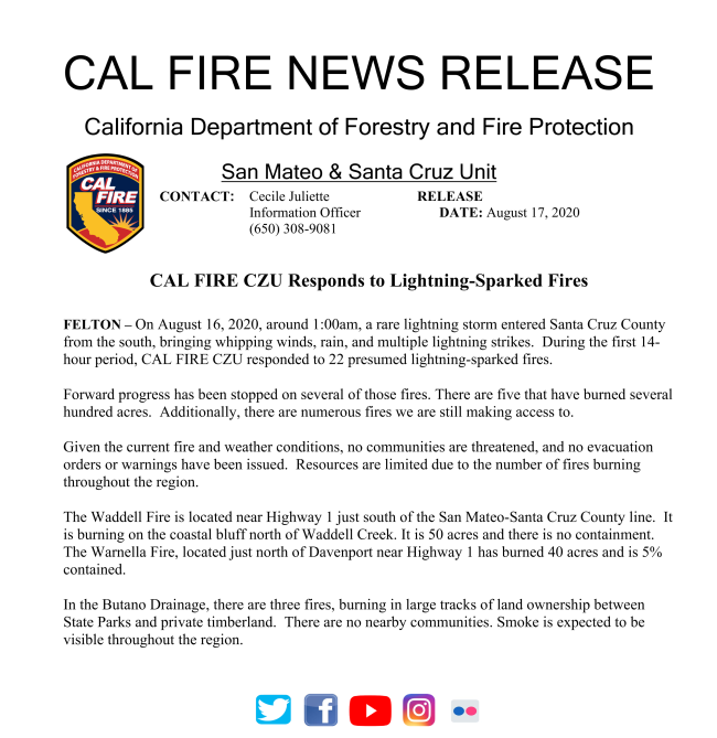
Cal Fire CZU update on the #EdgewoodFire as of 5:30 PM today Tuesday Jun-21-2022

https://twitter.com/calfireczu/status/1539407728715583488?s=21&t=E8v4PdwTbdhdvTm7SvcEWA
Edgewood Fire Summary Update - FIRE SAFE SAN MATE COUNTY

Edgewood_Fire_Summary_Update_-_FIRE_SAFE_SAN_MATE_COUNTY.pdf

Ducument availble to download at the link below.
Illegal_Firework_Starts_Grass_Fire_in_San_Mateo_Co.PDF

Dataset Names: San Mateo County Impervious Surfaces
Version: 2/10/2021
Download Location: ArcGIS Online (see table 1 below)
Credits: Golden Gate National Parks Conservancy, University of Vermont Spatial Analysis Lab, Tukman Geospatial LLC, Santa Cruz Mountains Stewardship Network, Midpeninsula Open Space District, CAL FIRE, San Mateo County Parks, San Mateo Office of Sustainability, San Mateo Dept. of Public Works, San Mateo Planning and Building Dept., San Mateo Information Services Dept., San Mateo Dept. of Agriculture Weights and Measures, San Mateo City/County Association of Governments
Access: Publicly Available
Appropriate Scale Range for Use: 1:1,000 and smaller
Dataset Summary:
The San Mateo County Impervious Surfaces map is a 5-class land use and land cover map of San Mateo County. The impervious map is a fine-scale polygon vector representation of all artificial impervious surfaces in San Mateo County. There are over 780,000 features in the dataset. Non-impervious areas are not mapped and are not covered by polygons. The impervious map represents the state of the landscape in summer, 2018. This data product was produced by the impervious mapping team at the University of Vermont Spatial Analysis Lab. Table 1 lists download locations for the dataset.
Table 1. Impervious surfaces availability
|
Description |
Link |
|
File GDB Feature Class |
|
|
ArcGIS Pro Layer Package |
|
|
Vector Tile Layer |
San Mateo County Impervious Surfaces – Selected Federal Lands 2
systems rulesets for impervious mapping included: orthophotography (2018), the lidar point cloud (2019), and Lidar derived rasters.
After it was produced using Trimble Ecognition, the preliminary impervious map product was manually edited by a team of UVM’s photo interpreters. Manual editing corrected errors where the automated methods produced incorrect results.
The impervious surfaces map reflects the state of the landscape in summer, 2018 when countywide high resolution imagery collection occurred.
The impervious map has 5 classes, which are described below:
• Buildings – Structures above 200 square feet in area. Structures fully occluded by vegetation will not be mapped.
• Paved Roads – Roads that are paved and wide enough for a vehicle.
• Dirt and Gravel Roads – Dirt or gravel roads wide enough for a vehicle. Non-ephemeral fire roads, ranch roads and long driveways.
• Other Dirt and Gravel – Dirt or gravel surfaces that are highly compacted and used by humans and equipment, such as parking lots, road pull-offs, some dirt or gravel paths, and highly compacted areas around commercial activities. This class DOES NOT include natural turf playing fields, very lightly used dirt roads, livestock areas, naturally occurring bare soil or rock, or bare areas around ponds.
• Other Paved – Includes parking lots, sidewalks, paved walking paths, swimming pools, tennis courts.
Miscellaneous quality control and processing notes:
• Zoom level used during manual quality control was no finer than 1 to 500.
• Vector data was created with no overlapping polygons.
San Mateo County Impervious Surfaces – Selected Federal Lands 3
Data Limitations:
This is not a planimetric data product and was created using semi-automated techniques. It provides a reasonable and useful depiction of impervious surfaces for planner and managers but does not have the accuracy or precision to support engineering. Appropriate uses of the data product include:
• As an input to storm water models
• For planners to assess % imperviousness in a parcel/watershed
• To help identify areas of human infrastructure for fuels and fire management
• As an input to fuel models that are used in fire behavior and fire spread models
• For cartography and mapping
• Generally for use at scales 1:1,000 and smaller
Inappropriate uses of this product include:
• Measuring exact square footage of structures or impervious features for building projects
• Using the impervious as geographically precise information in transportation and public works
Minimum Mapping Units:
|
The table below shows the nominal minimum mapping units (MMUs) for the impervious surfaces map. Map Class |
MMU |
|
Buildings |
200 square feet |
|
All Other Classes |
400 square feet |
Related Datasets:
The San Mateo County Roads, Trails, and Dozer Lines feature class includes centerlines for paved and dirt roads, trails, and CAL FIRE dozer lines in San Mateo County.
The datasheet and download links are available at vegmap.press/san_mateo_centerlines_datasheet
San Mateo County Impervious Surfaces – Selected Federal Lands
An analysis by The New York Times of satellite images, combined with on-the-ground surveys, provides a more complete picture of the origin, spread and devastation of the fire that killed at least 23 people in and around the city.
The Tubbs fire destroyed at least 5,200 homes and structures, shown on the map below, making it the most destructive wildfire in state history, as well as one of the deadliest. The Times analysis also shows how quickly the fire spread in the crucial initial hours.
Read a Press Democrat story about how the fire spread here and a look at the 911 calls received as the fire spread here. See all of the Press Democrat's fire coverage here.

The fire was pushed downhill at unusually high speeds by winds that sometimes exceeded 50 miles per hour. Burning embers were blown ahead of the main front, leaping ahead and igniting new fires.
In about three hours, the fire reached Santa Rosa, causing a chaotic scramble among authorities and unprepared residents.
One resident said that by the time the first emergency alert came, the flames were already marching toward his house, leaving just minutes to escape. As their city became engulfed in flames, many residents frantically fled their homes. But some people were unable to escape, and in many cases, their remains have been recovered inside or near their homes.
Sources: California Department of Forestry and Fire Protection; Sonoma County Vegetation and Habitat Mapping Program (building footprints); U.S. Geological Survey (fire perimeter); Broadcastify; National Oceanic and Atmospheric Administration; Cooperative Institute for Research in the Atmosphere; Mark Finney, Missoula Fire Sciences Laboratory, U.S. Forest Service; Neil Lareau, Department of Meteorology and Climate Science, San Jose State University; Scott Stephens, Department of Environmental Science, Policy and Management, U.C. Berkeley; Daniel Swain, Institute of the Environment and Sustainability, U.C.L.A.
By New York Times Staff Writers: Derek Watkins, Troy Griggs, Jasmine C. Lee, Haeyoun Park, Anjali Singhvi, Tim Wallace and Joe Ward.
Derek Watkins reported from Santa Rosa. Troy Griggs, Jasmine C. Lee, Haeyoun Park, Anjali Singhvi, Tim Wallace and Joe Ward reported from New York. Reporting was contributed by Susan C. Beachy and Richard Pérez-Peña from New York, Adam Nagourney from Los Angeles, and Carol Pogash from Santa Rosa.
Camp Fire –Fire Progression Timeline
San Mateo County, FireSafeCouncil

We are very lucky to have NIST’s, Alexander Maranghides present a report on the Camp Fire’s progression and time line of the fire and how the structures within the community of Paradise faired.
Video and Audio by computer: click this link https://zoom.us/j/8119100623
Video by computer, and Audio by phone: use the link above, then call phone number
669-900-9128 and enter Meeting ID: 811 910 0623
Audio by phone only: call phone number 669-900-9128 and enter Meeting ID: 811 910
0623
Agenda: 2021-11-10FIRE SAFE SAN MATEO COUNTY AGENDA-ONLINE-1.pdf
Presentation Announcement: Camp Fire _ Fire Progression Timeline Presentation Announcement_FSSMC.pdf
Presentation: Camp Fire Progression Timeline Chapter 7A 20210802-pdf.pdf
Presentations:
Passcode for video: t44=Fz6=
Chat Transcript ( many useful links shared by the Fire Safe Community ) tfire safe Oct 13.md.txt
Fire Safe
Aug 11th Don Bullard
Risk Assessment & Rust Day
Why is CA Burning
Please click here to access the video recording. When prompted, use the passcode: FbA.@6BU
Beginning July 1, 2021, AB38 requires a seller of real property located in a high or very high fire hazard severity zone to provide specified documentation to the buyer that the real property is in compliance with the wildfire protection measures described above or a local vegetation management ordinance, or enter into an agreement with the buyer pursuant to which the buyer will obtain documentation of compliance, as provided.
To request an inspection for properties in the SRA (State Responsibility Area managed by CAL FIRE), use the following link: https://www.fire.ca.gov/dspace
For properties in the LRA (Local Responsibility Area), work with your Realator or contact your local fire agency for more information.
Please use the link below to access the video recording. When prompted, used the passcode: Tu61&LMX
https://zoom.us/rec/share/Pg0-Fr1jY0oUN-EbPpSzK4QErfsu7feVj9fGP54QdxWa-3m6HrrBVRn1aC_Kjls.1U3WAMPPHbSJL4v6
At the June 9 Fire Safe San Mateo County meeting Danny Franco of the Golden Gate National Parks Conservancy presented a stakeholder update on the county vegetation map and landscape databse project. This project has already proven valuable to many stakeholders and partners to inform vegetation management. This information has also been used for grant proposal applications. In the near future post-fire digital imagery and data will be collected to capture information about the CZU Lightning Complex fires and inform recovery.
Click here to view the full presentation
Click here to view the technical report pubished January 2021 which discusses Fuel Model Maps and Fire Behavior Maps.

Please see below a letter from the Fire Safe President, Denise Enea.


At April's Fire Safe Council Meeting, there were two presentations, which were recorded and are available for download below.
Paul Hessburg, Ph.D., Research Ecologist, USDA-FS
Our wildfire problem; How we got here and What we can do about it
Sheena Sidhu, Ph.D., Erica Harris, and David Cowman, Forest Health and Fire Resiliency Program, San Mateo Resource Conservantion District (RCD)
Collaborative Forest Health and Fire Resiliency for San Mateo County
There will be an informational meeting for the Prescribed Burn Project planned for San Francisco Public Utilities Commission (SFPUC) land. The meeting will be Wednesday, March 24, 7pm-8pm
https://us02web.zoom.us/j/85223632957?pwd=bGdKTDM2K3dkKzV2Y1hZS0J2MGFOZz09
Webinar: 645149 Passcode: 645149
Or Telephone: 669-900-6833
Presenters:
Sarah Collamer, Forester I CAL FIRE
Richard Sampson, Forester II CAL FIRE
Jonathan Cox, Deputy Chief San Mateo
Jonathan Perrin, Peninsula Area Land Manager, SFPUC

SJSU Wildfire Interdisciplinary Research Center is hosting a Fire Weather Workshop, April 8-9, 2021

This year, the workship will have an extended speaker list of colleagues and partners from across the world to provide an international perspective on current fire weather reesarch. Sessions include: fuels and fire danager, remote sensing of fire environment, fire weather indices and case studies, coupled fire-atmosphere modeling advances, and smoke modeling and impacts. For more information vist the webiste (click here). Register here
Presentation: Changes in fire risk for climate change in San Mateo County.
Isabel Pares Ramos, San Mateo Office of Sustainability and LeRoy Westerling, UC Merced
Thanks to sponsorship from CAL FIRE, PGE, and local fire agencies, ALERTWildfire has installed several wildfire cameras in strategic locations throughout San Mateo county and the western United States.
ALERTWildfire is a consortium of three universities -- The University of Nevada, Reno (UNR), University of California San Diego (UCSD), and the University of Oregon (UO) -- providing access to state-of-the-art Pan-Tilt-Zoom (PTZ) fire cameras and associated tools to help firefighters and first responders: (1) discover/locate/confirm fire ignition, (2) quickly scale fire resources up or down appropriately, (3) monitor fire behavior through containment, (4) during firestorms, help evacuations through enhanced situational awareness, and (5) ensure contained fires are monitored appropriately through their demise.
To view wildfire cameras and get more information on ALERTWildfire, follow the link below:
Celia Hare of the Center for Employment Training (based in San Jose, CA) presented at the March Fire Safe Council meeting. She shared information about the 2020 August Wildfire Temporary Jobs Assistance Program which is currently serving San Mateo and Santa Clara Counties. This program is focused on public or non-profit land post-fire clean up by their crews.
At this time, the program is both identifying potential job sites and recruiting people for the program.
If you are interested in leanring more, please reach out to Celia Hare: This email address is being protected from spambots. You need JavaScript enabled to view it. or (408) 534-5339

The Central Coast Prescribed Burn Council (CCPBA) is hosting Prescribed Firelighter and Wildland Firefighter Training.
The workshop will be held in three locations:
These are all day events 9:00am - 5:00pm
Register here: Prescribed Firelighter and Basic Wildland Firefighter Training (ucanr.edu)
California's Wildfire and Forest and Resilience Action Plan was released January 2021 by the Forest Management Task Force. It is a call to action for California's growing forest and wildfire crisis. It is designed to strategically accelerate efforts to:
Link here: https://fmtf.fire.ca.gov/media/cjwfpckz/californiawildfireandforestresilienceactionplan.pdf

Matteo Garbelotto will be giving a talk called "Living with Fire" on December 12, 2020 at 10am.
Dr. Garbelotto has previously spoken on Sudden Oak Death at a previous Fire Safe San Mateo County meeting. He is inviting anyone interested to register and attend.
Register here: https://berkeley.zoom.us/meeting/register/tJEocuuurTorGdeDT62OM4oiFEXla-tZrSQA
Website with more information: http://www.ucbfire.org
The Amah Mutsun Land Trust is hosting their first ever fire symposium online on November 19, from 3:00 - 4:30 PM.
The event will bring together tribal leaders, fire researchers, archaeologists, and others for a discussion on coastal Central California's fire history, prescribed burning, and Indigenous fire stewardship. Event details and registration information can be found here:
https://www.amahmutsunlandtrust.org/events/2020/11/19/amlt-fire-symposium
Fire Safe San Mateo County would like to share this article with the Fire Safe Council membership from Wildfire today by Jack Cohen and Dave Strohmaier.
Community destruction during extreme wildfires is a home ignition problem

VOLUNTEERS NEEDED! SIGN UP HERE!!
Drop off chipping event for Loma Mar and Dearborn Park. Two weekends in November. Drop off your material between 10am-4pm on the following dates at Redwood Glen, 100 Wright Drive, Loma Mar, CA

Curb-side chipping event in the Highlands neighborhood.
Chipping will be available for half of the residents on November 16 and half on November 18. Residents should recieve brochures (linked below) indicating what date their house will be eligible for the chipping service.
The Tahoe RCD is hosting a virtual workshop for building professionals on retrofitting and building homes to withstand wildfire and are hoping you can share the flyer (attached) with building professionals you work with! The workshop isn't specific to any one geography and will apply to all building professionals working in wildfire-prone areas. Please reach out directly to Carlie Murphy, the Fire Adapted Communities Coordinator (This email address is being protected from spambots. You need JavaScript enabled to view it.), if you have any questions.

Drop off chipping event for Loma Mar and Dearborn Park. Two weekends in November. Drop off your material between 10am-4pm on the following dates at Redwoo Glen, 100 Wright Drive, Loma Mar, CA

Drop off chipping event for La Honda. Three weekends in November. Drop off your material between 10am-4pm on the following dates at Cuesta La Honda.

Curb-side chipping event for select streets in Montara and Moss Beach

Wildfire Resilience: Best Practices in Real Estate and Land Use by Global ULI Online. October 30, 2020. LINK HERE:
https://americas.uli.org/events/detail/163A8649-80C3-47C7-8549-ED18318357D1/ /
This event has a general focus on a nation-wide audience about how the real estate industry is responding to increasing wildfire risks and impacts with building design, land use policy, and community resilience solutions.
The Virtual Wildland Urban Interface (#VirtualWUI) conference is being hosted by the International Association of Fire Chiefs on November 4-5, 2020. LINK HERE: https://www.eventscribe.com/2020/WUI/index.asp
We encourage you to review the schedule to identify interesting presentations. Several sessions are concurrent, so if you attend one, it would be great if you could report back a summary to the council at our next Fire Safe San Mateo County (FSSMC) meeting. (please note, times follow the Eastern Time Zone). Register Here.
Message from Good Fire Alliance:
Fire Forward has scheduled two additional Basic Wildland Firefighter (and Firelighter) Training field days – one for March 6 and one for March 7. If you’d like to attend, please sign up at either of the registration links below, share with folks who may be interested, and make sure you get an early start on the online prerequisite work required for the field day (about 35-40 hours of online training material hosted by NWCG and FEMA). We hope to see you there!
March 6, 2021:
https://www.eventbrite.com/e/123957250473
March 7, 2021:
https://www.eventbrite.com/e/123957962603
A limited number of fee waivers are available on an as needed basis; email This email address is being protected from spambots. You need JavaScript enabled to view it. (Fire Forward Director) for more information.
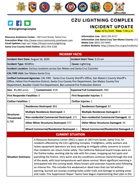
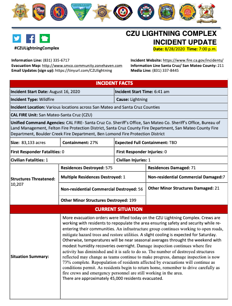
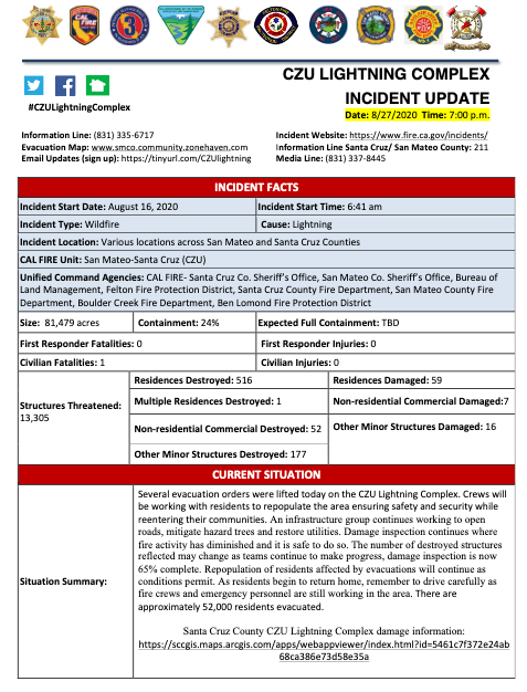
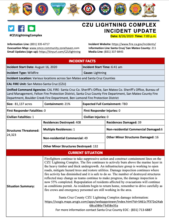
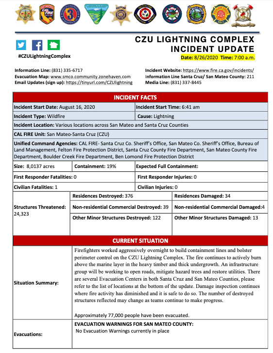
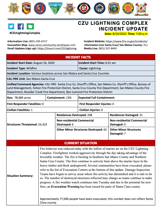
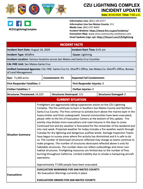
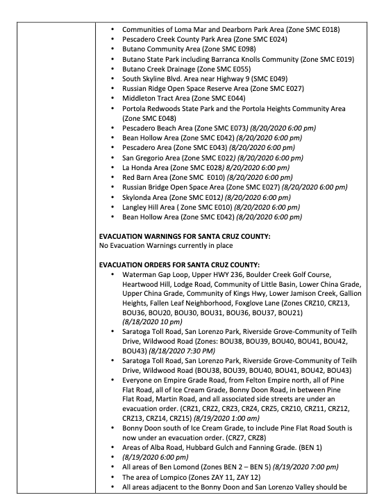
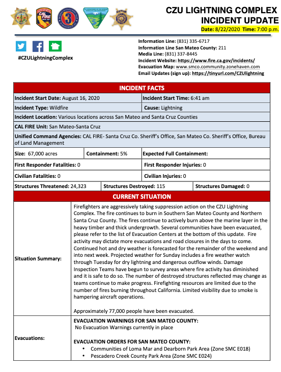
Incident Website: https://www.fire.ca.gov/incidents/
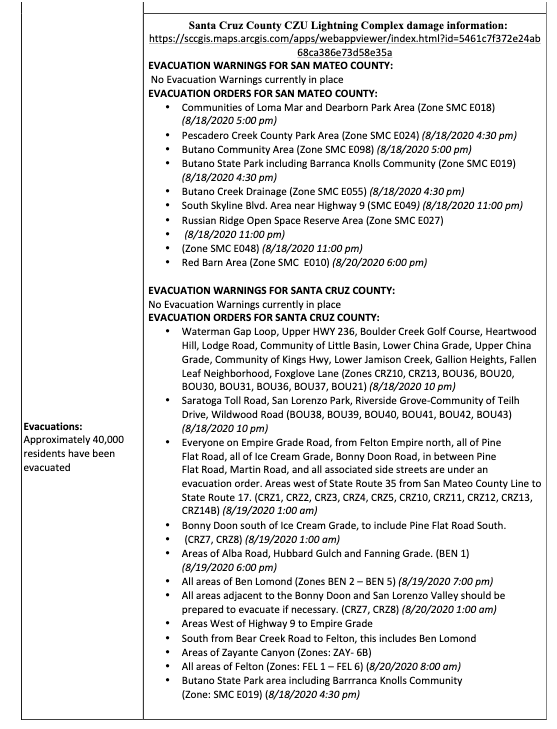
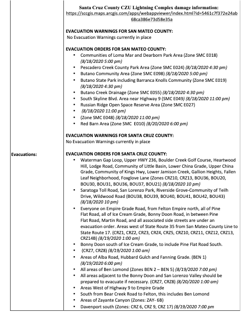
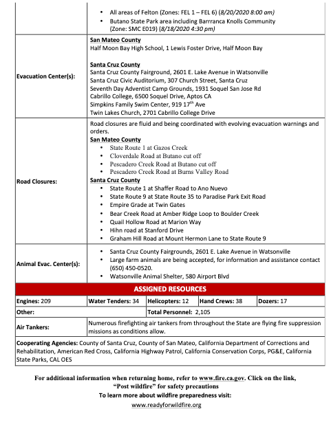
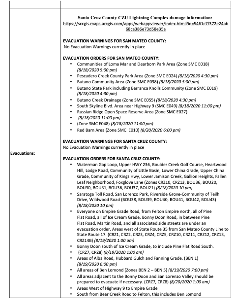
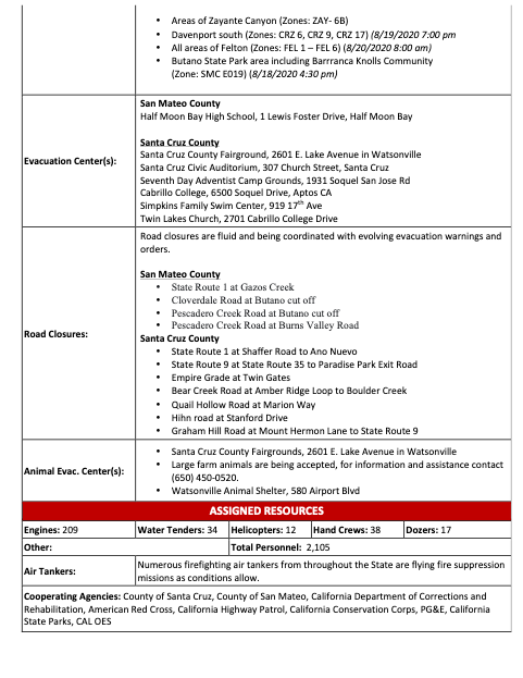
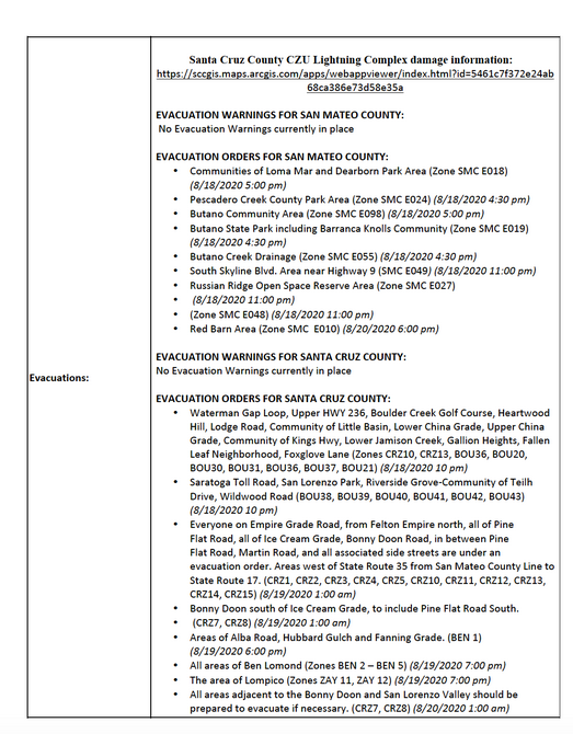
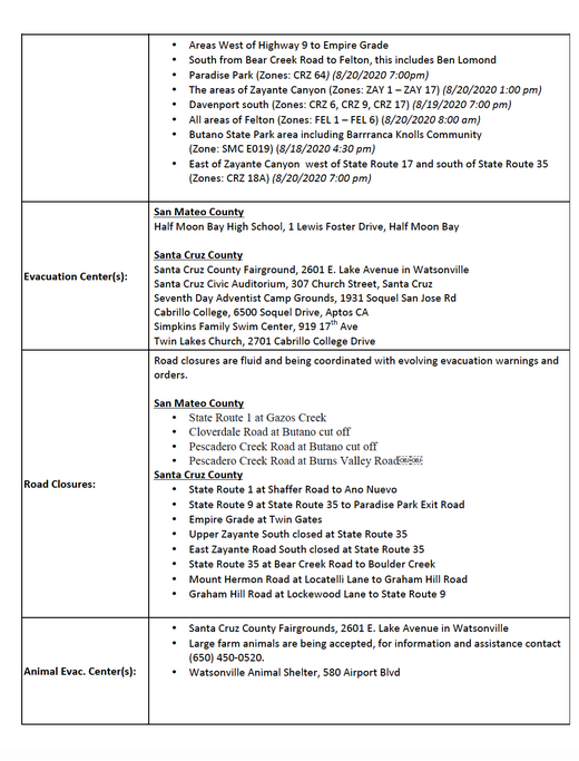
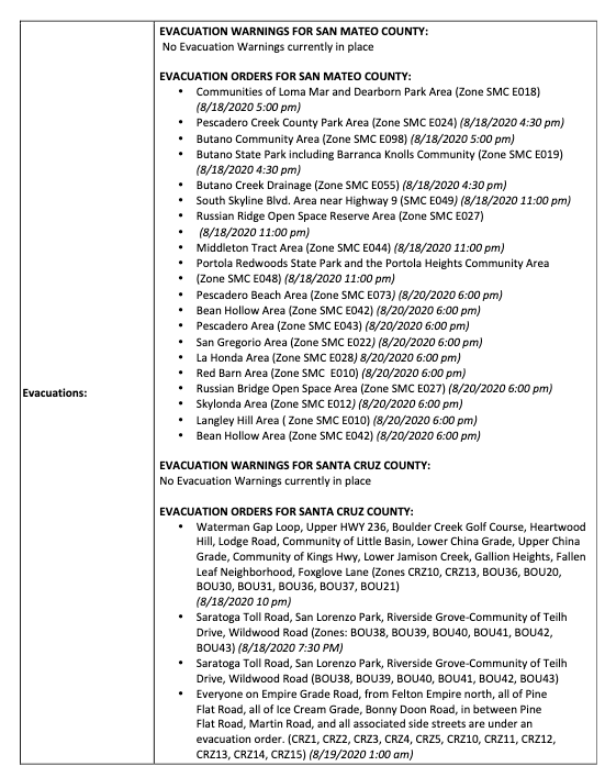
Evacuation and Repopulation Map:www.smco.community.zonehaven.com
Email Updates: https://tinyurl.com/CZULightning
Information LIne: 831-335-6717

Incident Website: https://www.fire.ca.gov/incidents/
Evacuation and Repopulation Map:www.smco.community.zonehaven.com
Link to press conference (in English): https://www.pscp.tv/CALFIRECZU/1MnxndgNbBEGO
Incident Website: https://www.fire.ca.gov/incidents/
Evacuation and Repopulation Map:www.smco.community.zonehaven.com
Link to press conference (in English):https://www.pscp.tv/CALFIRECZU/1BRJjYLVjLpGw
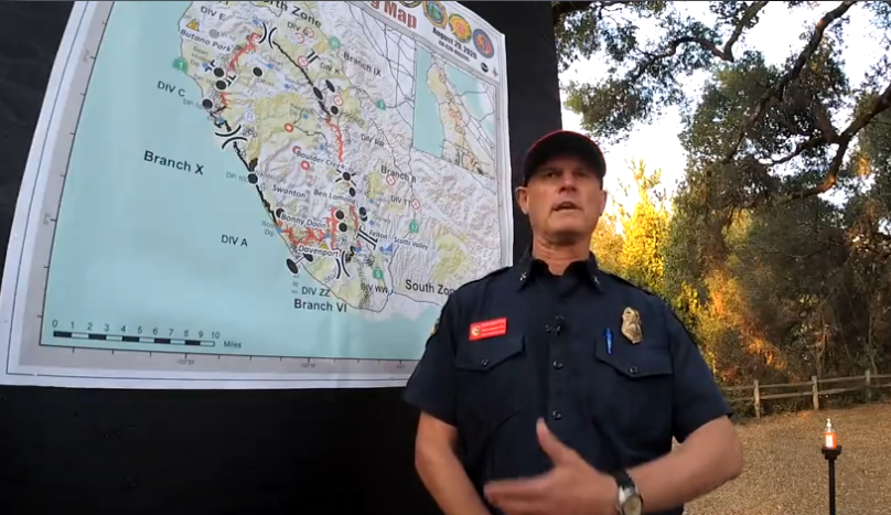
On August 29, 2020 Battalion Chief Mark Brunton did a live social media Q&A. Listen to him answer questions about preventing the fire from spreding to Santa Clara County, and long-term things you can do, which includes ensuring you have defensible space around your home, especially in the WUI (wildland urban interface), and getting involved with your local Fire Safe Council to help identify fuel reduction projects in your community!
Incident Website: https://www.fire.ca.gov/incidents/
Evacuation and Repopulation Map:www.smco.community.zonehaven.com
Link to press conference (in English): https://www.pscp.tv/CALFIRECZU/1BRKjYLanXRxw
Incident Website: https://www.fire.ca.gov/incidents/
Evacuation and Repopulation Map:www.smco.community.zonehaven.com
Returning home after wildfires resource: https://firesafesanmateo.org/news/entry/be-safe-when-returning-from-home-after-a-wildfire-cal-fire-readyforwildfire-org-post-wildfire-resources
Important safety measures to take when returning home after a wildfire, from CAL FIRE Ready for Wildfire.org. Visit website for more information and return home checklist.
Incident Website: https://www.fire.ca.gov/incidents/
Evacuation and Repopulation Map:www.smco.community.zonehaven.com
Video update (press confernce) in English: https://www.pscp.tv/CALFIRECZU/1dRJZZbjnwMJB
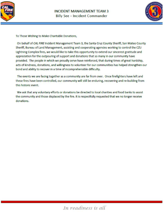
A message from Fire Safe Council president, Denise Enea, on Day 11 of CZU LIghtning Complex Fire indident. (Clickable links available below the letter)
DONATIONS
Puente which supports south coast families: https://mypuente.org
Coastside Hope supports SMC coastside residents: https://coastsidehope.org
ALAS (Ayudando Latinos A Soñar), supporting families, farmworkers, and youth of thecoastside: https://www.alashmb.org
ANIMALS ARE IN NEED TOO
Woodside Community Foundation Large animal & Livestock assistance resulting from the fire. For more information call Rick DeBenedetti, (650) 303-2661. Online donations
accepted: Woodsidegiving.org
Peninusla Human Society accepting donations of pet food, cat litter, newspapers at their Coyote Point Shelter. 12 Airport Blvd, San Mateo as well as financial donations https://phs-spca.org
San Mateo County Large Animal Evacuation Group is also requesting help to feed displaced animals. (note: not tax deductable). https://smclaeg.org
DONATE TO LOCAL VOLUNTEER FIRE DEPARTMENTS
Loma Mar Fire Department https://lomamarfire.org/donate
8879 Pescadero Creek Road , Loma Mar California United States 94021
Kings Mountain Fire Brigade http://www.kingsmountainonline.com/kmvfb
13889 Skyline Blvd. Woodside, CA 94062
La Honda Fire Brigade https://www.lahondafire.org/donate
8945 La Honda Rd, La Honda, CA 94020
VIDEOS
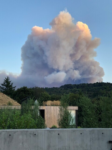
Fire Video https://www.dropbox.com/s/75lkl3trs9oboab/Butano%20Ridge%20Fire%208-18-20.m4v?dl=0
Lightning Storm https://www.dropbox.com/s/pzw8u3iibh9ps96/Lightening%20Over%20Portola%20Valley%208-16-20.m4v?dl=0
Incident Website: https://www.fire.ca.gov/incidents/
Evacuation and Repopulation Map:www.smco.community.zonehaven.com
Video update (press confernce) in English: https://www.pscp.tv/CALFIRECZU/1DXGyAOjQRgGM
Battalion Chief Mark Brunton
Incident Website: https://www.fire.ca.gov/incidents/
Evacuation Map:www.smco.community.zonehaven.com
Email Updates (sign up here): https://tinyurl.com/CZUlightning
Video update (press confernce) in English: https://www.pscp.tv/CALFIRECZU/1dRKZZnNnqAKB
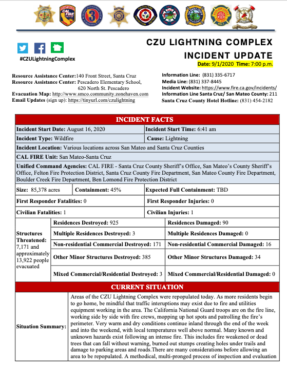
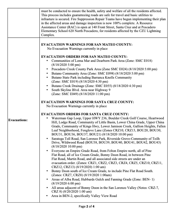
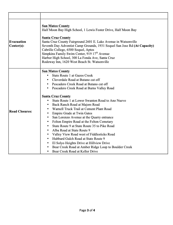
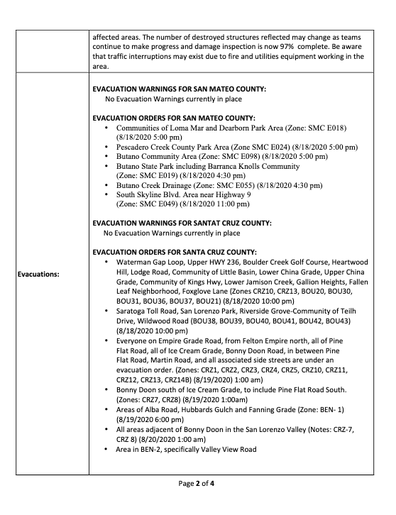
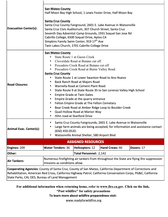
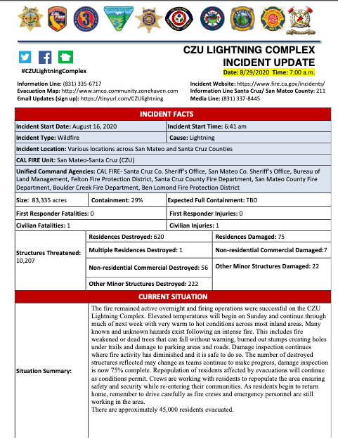
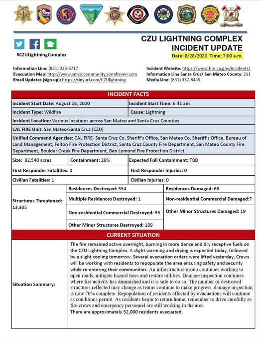
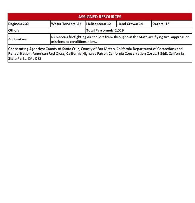
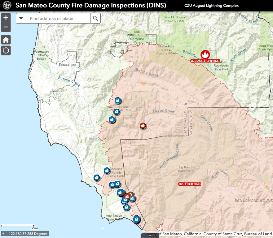
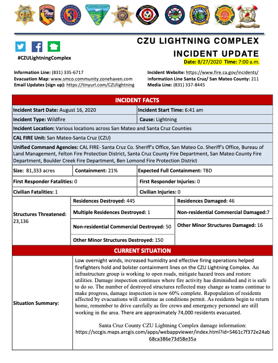
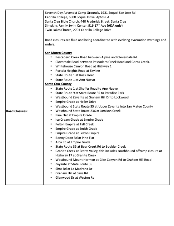
Fire damage inspection data for this map is provided by CALFIRE CZU Lightning Complex Fire Damage Inspections (DINS) database that captures the location, attributes, and damages status of structures within and immediately outside of the CZU Lightning Complex fire perimeter. The damage inspection data should be considred prelininary. Assessments are ongoing and subject to change as more ccrews are able to safely access new areas and as additionla information is gathered, anlayzed, and verified.
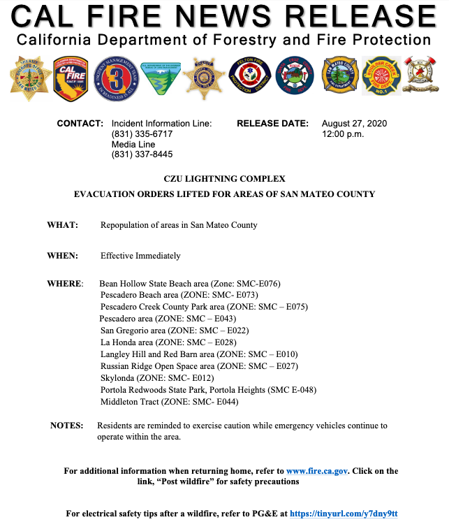
Repopulation has started for northern part of the CZU evacuation zone area outside of the fire perimeter. See map to view green zones: smco.community.zonehaven.com
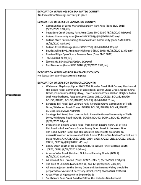
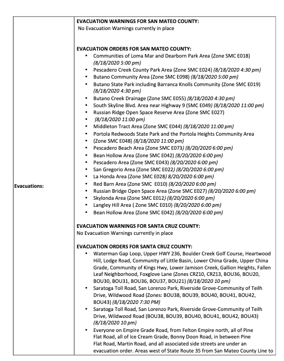
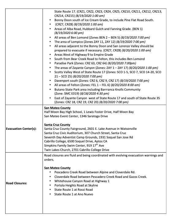
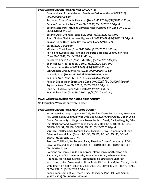
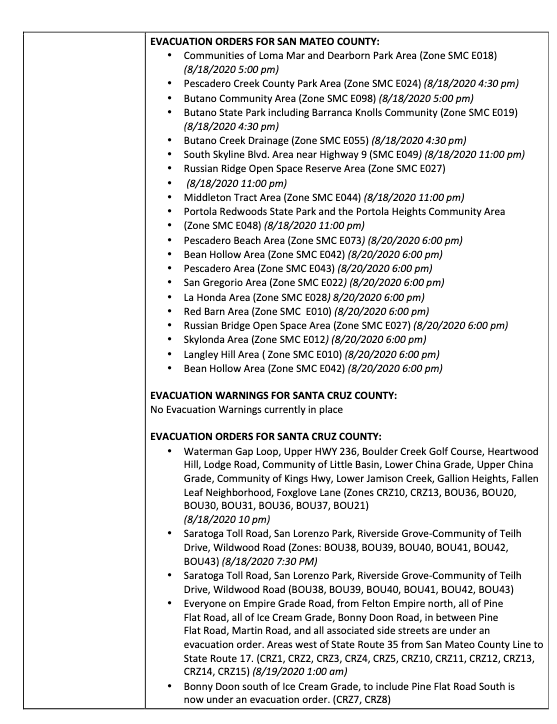
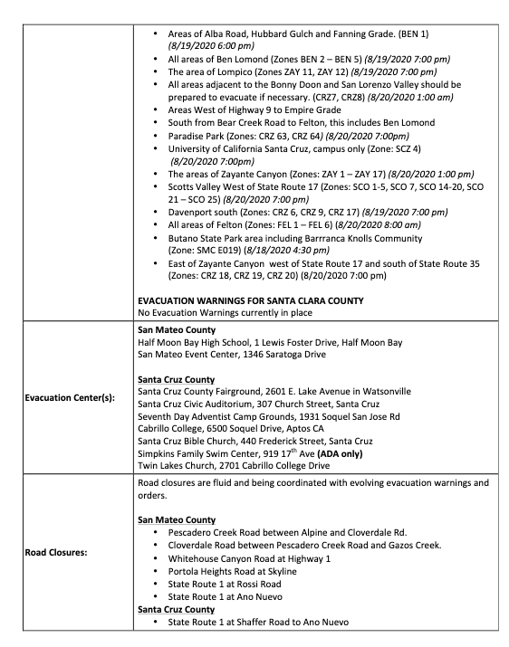
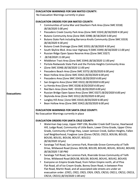
Orders have been lifted for the following communities:
CAL FIRE and partnering agencies are presently evaluating zones within the burn perimenter for safety, which includes roadways, water, and electricity. Evacuation orders will be lifted for additional zones in the coming days to weeks as zones continue to be evaluated and secured.
Incident Website: https://www.fire.ca.gov/incidents/
Evacuation Map:www.smco.community.zonehaven.com
Email Updates (sign up here):
Video update (press confernce) in English: https://www.pscp.tv/CALFIRECZU/1rmxPYqeOZYKN
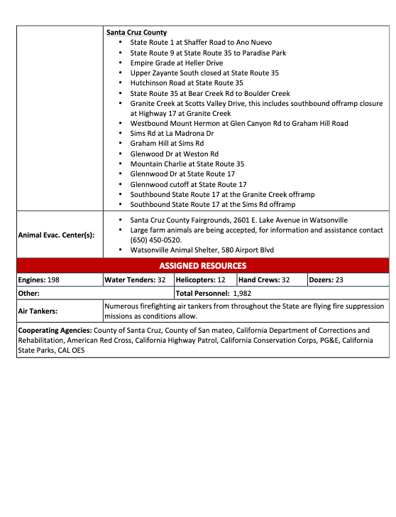
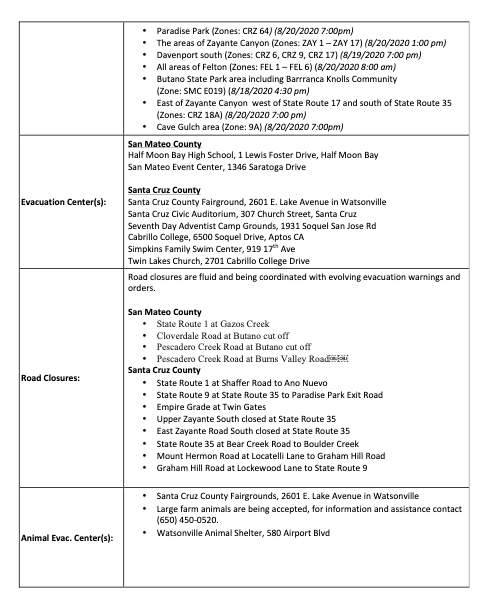
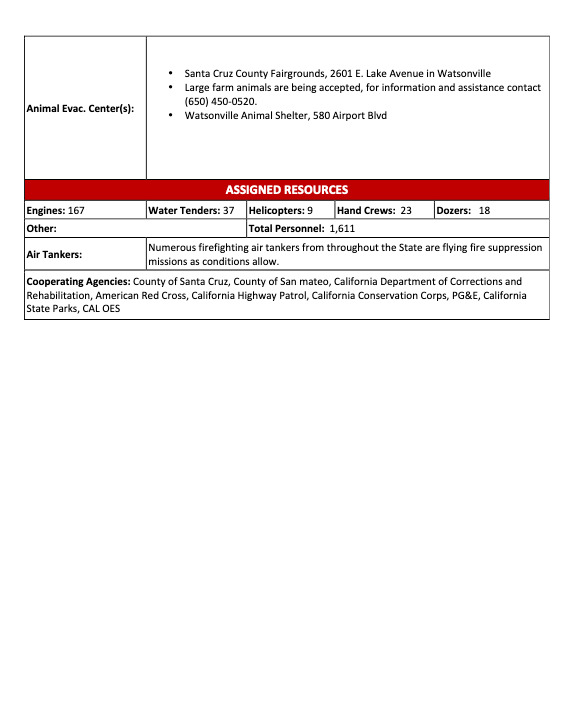
Pictures from earlier this week of feed being delivered to evacuated horses and cows at the Mounted Patrol grounds in Woodside. Donation was generated by the Woodside Community Foundation Giving Fund.
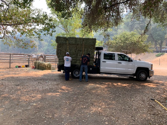
Feed being delivered by pick up truck and unloaded by two volunteers
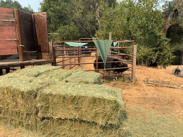
Feed in front of two evacuated cows at Mounted Patrol grounds
Two horses at Mounted Patrol grounds
Incident Website: https://www.fire.ca.gov/incidents/
Evacuation Map:www.smco.community.zonehaven.com
Email Updates (sign up here):https://tinyurl.com/CZUlightning
Video update (press confernce) in English: https://www.pscp.tv/CALFIRECZU/1DXxyAOXreRxM
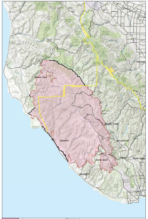
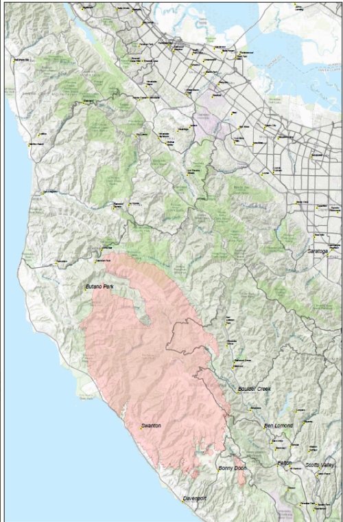
Perimeter map as of August 26, 2020
Incident Website: https://www.fire.ca.gov/incidents/
Evacuation Map:www.smco.community.zonehaven.com
Email Updates (sign up here):https://tinyurl.com/CZUlightning
Video update (press conference) in English: https://www.pscp.tv/CALFIRECZU/1mrxmEmejQZxy
Video update en Español: https://youtu.be/QJMbSQ19HWg
Incident Website: https://www.fire.ca.gov/incidents/
Evacuation Map: www.smco.community.zonehaven.com
Email Updates (sign up here): https://tinyurl.com/CZUlightning
Video update in English: https://youtu.be/n3SJhoxRIhc
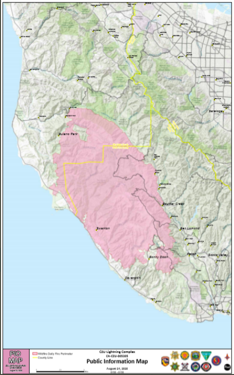
CAL FIRE public information perimeter map - August 24, 2020
high resolution map, click here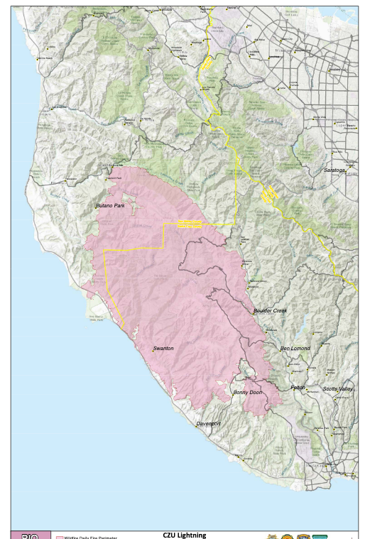 .
.
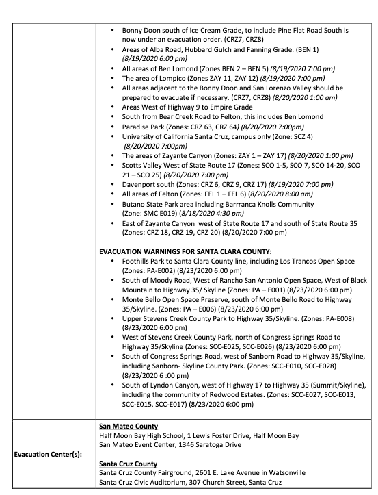
Link to incidence map (note: may take time to load): https://wildfirerecovery.caloes.ca.gov/current-incidents/
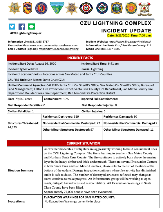
The current status of California fires since August 15, 2020 (information curent as of August 25, 2020). source: CZU Lightning Complex press conference Aug 25.
Incident Website: https://www.fire.ca.gov/incidents/
Evacuation Map: www.smco.community.zonehaven.com
Email Updates (sign up here): https://tinyurl.com/CZUlightning
Video of update, in English: https://www.youtube.com/watch?v=Hu2EaUdPnmI
Video update, en Español: https://youtu.be/KffU8aPrtuo

Incident Website: https://www.fire.ca.gov/incidents/
Evacuation Map: www.smco.community.zonehaven.com
Email Updates (sign up here): https://tinyurl.com/CZUlightning
To support our fellow community members, consider donating to:
Puente, which supports south coast families: https://mypuente.org
Coastside Hope, supports San Mateo County coastside residents: https://coastsidehope.org
ALAS (Ayudando Latinos A Soñar), supporting families, farmworkers, and youth of the coastside: https://www.alashmb.org
**note: goods are NOT being accepted at evacuation centers. Financial contributions are the highest need
Animals are in need too:
Woodside Community Foundation is focused on rasing funds for large animal rescue resulting from these fire. For more information call Rick DeBenedetti, (650) 303-2661. Online donations accepted here: Woodsidegiving.org
Peninusla Human Society is accepting donations of pet food, cat litter, newspapers at their Coyote Point Shelter. 12 Airport Blvd, San Mateo. and financial donation here: https://phs-spca.org
San Mateo County Large Animal Evacuation Group is also requesting help to feed displaced animals. (note: not tax deductable). https://smclaeg.org/
Incident Website: https://www.fire.ca.gov/incidents/
Evacuation Map: www.smco.community.zonehaven.com
Email Updates (sign up here): https://tinyurl.com/CZUlightning


Residents impacted by the CZU Lightning Complex fires are redirected to nearby locations for mail pic up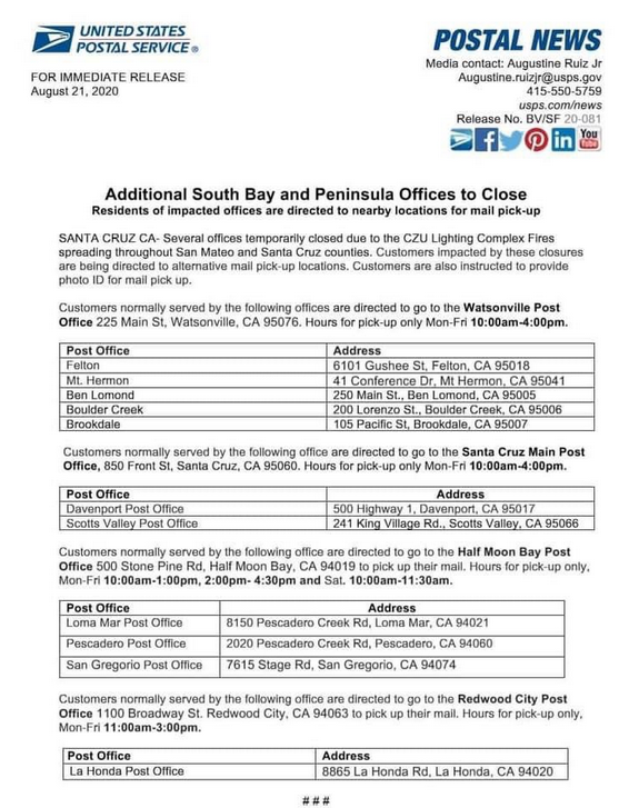
Incident Website: https://www.fire.ca.gov/incidents/
Evacuation Map: www.smco.community.zonehaven.com
Email Updates (sign up here): https://tinyurl.com/CZUlightning


Available maps and data to help assess air quality resulting from fires
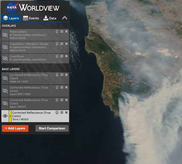
Actual image of smoke: NASA satellite image
Air quality (based on frequently updated measures of particulate matter): purpleair.com
Air quality from US EPA (includes a mix of high and low-cost sensor which measure particulate matter): Fire and Smoke Map
Spare the Air info and Air Quality Index maps through Bay Area Air Quality Management District (BAAQMD)
Air Quality Forecasts (table format) through BAAQMD and sign up for AirAlerts
NOAA (National Oceanic and Atmospheric Administration) Air Quality Forecast Guidance (map format- change menu option to "surface smoke")
Incident Website: https://www.fire.ca.gov/incidents/
Evacuation Map: www.smco.community.zonehaven.com
Email Updates (sign up here): https://tinyurl.com/CZUlightning
Incident Website: https://www.fire.ca.gov/incidents/
Evacuation Map: www.smco.community.zonehaven.com
Email Updates (sign up here): https://tinyurl.com/CZUlightning
Evacuation website from CAL FIRE: https://www.readyforwildfire.org/prepare-for-wildfire/go-evacuation-guide/evacuation-steps/
CAL FIRE evacuation guide: https://www.readyforwildfire.org/wp-content/uploads/calfire_go_brochure_LINOweb.pdf
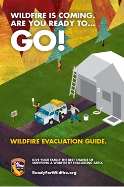
When immediate evacuation is necessary, follow these steps as soon as possible to get ready to GO!
Leave as soon as evacuation is recommended by fire officials to avoid being caught in fire, smoke or road congestion. Don’t wait to be ordered by authorities to leave. Evacuating the forest fire area early also helps firefighters keep roads clear of congestion, and lets them move more freely to do their job. In an intense wildfire, they will not have time to knock on every door. If you are advised to leave, don’t hesitate!
Do not return to your home until fire officials determine it is safe. Notification that it is safe to return home will be given as soon as possible considering safety and accessibility.
To support our fellow community members, consider donating to:
Puente, which supports south coast families: https://mypuente.org
Red Cross: RedCross Bay Area Chapter
Please also consider donating to local food banks.
Animals are in need too:
Peninusla Human Society is accepting donations of pet food, cat litter, newspapers at their Coyote Point Shelter. 12 Airport Blvd, San Mateo. and financial donation here.
The San Mateo County Large Animal Evacuation Group is also requesting help to feed displaced animals. see below for message from SMCLAEG:
Please call Pastorino's Hay and Feed at 650 726-6155 and/or Western Saddlery at 925 460-0373 and let them know you'd like to have them charge a $$ amount to your credit card...from there the Evac group can get hay and essentials to these displaced animals. Please let them know you are calling on behalf of the San Mateo County Large Animal Evacuation Group. SMCLAEG is not a 5013C so this is not tax deductible at this time but right now they just need to feed these animals.
Please see message below fromm CAL FIRE Incident Commander about donations to CAL FIRE

Cow Palace has become a large animal evacuation center in response to the CZU Lightning Complex fire.
Please call: 650-420-4121
You may also call the San Mateo County Large Animal Evacuation Group for Assistance: https://smclaeg.org
Laura: 650-450-0520
Robin: 650-450-0516
Emilie: 650-773-8780
The San Mateo County Large Animal Evacuation Group is also requesting help to feed displaced animals. see below for message from SMCLAEG:
Please call Pastorino's Hay and Feed at 650 726-6155 and/or Western Saddlery at 925 460-0373 and let them know you'd like to have them charge a $$ amount to your credit card...from there the Evac group can get hay and essentials to these displaced animals. Please let them know you are calling on behalf of the San Mateo County Large Animal Evacuation Group. SMCLAEG is not a 5013C so this is not tax deductible at this time but right now they just need to feed these animals.
Incident Website: https://www.fire.ca.gov/incidents/
Evacuation Map: www.smco.community.zonehaven.com
Email Updates (sign up here): https://tinyurl.com/CZUlightning


Link to map AND evacuation zone here: https://storymaps.arcgis.com/stories/f0121f7f2f0941afb3ed70529b2cee75
Below, Incident Map as of August 21
Incident Website: https://www.fire.ca.gov/incidents/
Evacuation Map: www.smco.community.zonehaven.com
Email Updates (sign up here): https://tinyurl.com/CZUlightning


A Message from Fire Safe San Mateo County president Denise Enea in reponse to CZU Lightning Complex Fires.
Evacuation program- Zonehaven https://storymaps.arcgis.com/stories/f0121f7f2f0941afb3ed70529b2cee75
Please sign up to receive digital Cal Fire messages https://tinyurl.com/CZUlightning
San Mateo County’s emergency notification system https://hsd.smcsheriff.com/smcalert
Santa Cruz County’s emergency notification system http://scr911.org/
Fire Area Map https://maps.nwcg.gov/sa/#/%3F/%3F/37.6144/-122.136/10
Fire Video https://www.dropbox.com/s/75lkl3trs9oboab/Butano%20Ridge%20Fire%208-18-20.m4v?dl=0


CAL FIRE and emergency services are using ZoneHaven for evacuation maps. These are the official maps used by San Mateo County for emergency response.
https://smco.community.zonehaven.com
If you are having difficulties using the map, please see the instructions below.

Put together your emergency supply kit and have it accessible so you can take it with you when you have to evacuate. Learn more: https://www.readyforwildfire.org/prepare-for-wildfire/get-set/emergency-supply-kit/

Incident Website: https://www.fire.ca.gov/incidents/
Evacuation Map: www.smco.community.zonehaven.com
Email Updates (sign up here): https://tinyurl.com/CZUlightning


For the most up-to-date evacuation maps and orders, please see: https://smco.community.zonehaven.com
Please note: Evacuation Order means leave IMMEDIATELY, and Evaucation Warning mean prepare to leave if ordered.
To receive email updates, sign up here: https://tinyurl.com/CZUlightning
To receive text alerts, sign up with SMC Alert System: https://hsd.smcsheriff.com/smcalert

Incident Website: https://www.fire.ca.gov/incidents/
Evacuation Map: www.smco.community.zonehaven.com
Email Updates (sign up here): https://tinyurl.com/CZUlightning


For the most up-to-date evacuation maps and orders, please see: https://smco.community.zonehaven.com
Please note: Evacuation Order mean leave IMMEDIATELY, and Evaucation Warning mean prepare to leave if ordered.
To receive email updates, sign up here: https://tinyurl.com/CZUlightning
To receive text alerts, sign up with SMC Alert System: https://hsd.smcsheriff.com/smcalert


Please see letter below from Denise Enea, president of Fire Safe San Mateo County
Sign up for Cal Fire email messages here: https://tinyurl.com/CZUlightning
Sign up for SMC text alerts here: https://hsd.smcsheriff.com/smcalert

For the most up-to-date evacuation maps and orders, please see: https://smco.community.zonehaven.com
To receive email updates, sign up here: https://tinyurl.com/CZUlightning
To receive text alerts, sign up with SMC Alert System: https://hsd.smcsheriff.com/smcalert


Incident Website: https://www.fire.ca.gov/incidents/
Evacuation Map: www.smco.community.zonehaven.com
Email Updates (sign up here): https://tinyurl.com/CZUlightning


PG&E has provided information about their Community Wildfire Safety Program, which includes information for residents.
Please follow the link here: Community Wildfire Safety Program.

Earlier this year, Stanford's Bill Lane Center for the American West had planned an in-person Workshop on Wildfire Management. It was reformated into a virtual workshop that includes a recorded keynote presentation "What Motivates Homeowners to Mitigate Fire Risk? Lessons from Social Science" and two recorded pannel discussions, "Wildfire Management and Preparation during the COVID-19 Pandemic" and "Preparedness adn Recovery: The Human Dimensions of Wildfires". In addition, there are student poster presentations of original wildfire-related research available for viewing.
Please follow the link to access this resource: Wildfire in the West: Workshop on Wildfire Management (virtual format)
At the March Fire Safe meeting, Dr. Matteo Garbelotto of UC Berkeley presented the lates information about SOD (Sudden Oak Death) and its relationship to fire ecology (please see meeting notes from March 2020 for a recap). Dr. Garbelotto also invited anyone interested to participate in the annual SOD Blitz which is run by his research program at UC Berkeley.
In light of the recent COVID-19 shelter-in-place order, Dr. Garbelotto provided us an update that the SOD Blitzes for 20202 will still be running, using new and approved guidelines.
Copied below is his message with more details:
March 31st, 2020
Concerned Californians, nature-lovers and environmentalists,
You are receiving this email because in the past you have attended one of the many programs offered by the U.C. Berkeley Forest Pathology and Mycology Laboratory (www.matteolab.org<http://www.matteolab.org>). I know many of you have participated in at least one annual SOD Blitz. SOD Blitzes have grown to become the gold standard in the field of Citizen Science programs aimed at protecting forest health, and you –the volunteers- are the main reason for this success. SOD Blitzes allow us to map the distribution of Sudden Oak Death (SOD) throughout the State each year. Mapping SOD in 2020 may be critical for various reasons: 1)- Areas with recent SOD mortality are much more prone to support extremely hot wildfires; 2)- SOD infected oaks fail, often when still green, with obvious consequences for property and people; 3)- Knowing where SOD is, allows local residents to choose to protect their oaks using science-proven disease management options; 4)- Two new strains of the diseases are looming at the edge of California forests and the SOD Blitzes are the only way to intercept them before they spread. These new strains could be a game changer in the negative sense of the expression.
In spite of the ongoing health scare and of the statewide “Shelter in Place” ordinance, we have been able to redesign the 2020 SOD Blitzes to make them 100% safe and legal, an effective activity that allows you to exercise, and –of course- a powerful Citizen Science program that will help all of us protecting our forests. The program has received full approval by U.C. Berkeley and it will go on as long as we all follow the simple guidelines posted at www.sodblitz.org<http://www.sodblitz.org>. All of the training and free registration will be done online, you will pick up fully sterile collection and survey materials at a local SOD Blitz Station, conveniently located near a parking lot, and you will return your samples at the same SOD Blitz station or by mail, depending on where you are. All the precise information is available at www.sodblitz.org<http://www.sodblitz.org>. Remember, by participating in your local SOD Blitz, you will get a chance to exercise in nature while helping protecting our forests through a 100% safe activity.
Social distancing and clean “housekeeping” rules are strongly enforced, so when picking up or returning materials and stay at least 6 feet away from other volunteers. You will be allowed to survey and sample trees in private properties with the owners’ consent, along roads (be mindful of approaching vehicles), and in parks that may still be open to the public. Again, respect social distancing rules in the field as well. Do participate, because Sudden Oak Death is not stopping and we need to be proactive about it in order to succeed in our efforts to preserve our beloved oaks for future generations. In 2019 alone, more than one million trees were killed by SOD. Go to www.sodblitz.org<http://www.sodblitz.org> to familiarize yourselves with the easy-to-follow new SOD Blitz guidelines, and to find out the time slot that has been assigned to your neighborhood to perform the survey. This is an activity you can do with the entire family or with one friend: do not miss out the opportunity to be part of the solution.
Matteo Garbelotto Ph.D.
Director U.C. Berkeley Forest Pathology and Mycology Laboratory Statewide U.C. Forest Pathology Extension Specialist Adj.Professor, Department of ESPM www.matteolab.org<http://www.matteolab.org>
Mipeninsula Regional Open Space District wiil be having a virtual public meeting about their Wildland Fire Resiliency Program. This is an opportunity to learn more and provide actions.
Information from Midpen:
Now is a great time to comment on the Midpeninsula Regional Open Space District's Wildland Fire Resiliency Program.This proposed program will proactively expand our environmentally sensitive vegetation management to establish healthy, resilient ecosystems; reduce fire risk; and facilitate fire suppression.
Please join Midpen's board of directors for a study session:
Wednesday, April 8, 2020, 5-7 p.m.
Virtual meeting, click here for details<https://openspace.us1.list-manage.com/track/click?u=cf60d90ac20de1d557d559b1e&id=a02e2e2fa4&e=fa82987005>
No board action will be taken
This is an opportunity to learn more about and comment on program components including:
Due to shelter-at-home orders this will be a virtual meeting. Details and instructions on how to comment and participate<https://openspace.us1.list-manage.com/track/click?u=cf60d90ac20de1d557d559b1e&id=4bf75f5b33&e=fa82987005> can be found on our website.
For more information contact project manager Coty Sifuentes-Winter at This email address is being protected from spambots. You need JavaScript enabled to view it. or 650-625-6560.
Check out a few upcoming events of interest to FIRE SAFE San Mateo County members! These events are not affiliated with FIRE SAFE San Mateo County, but are wonderful opportunity for members to learn and network throughout the region.
Protecting Your City from Wildfire
Crowne Plaza San Diego
Wednesday, March 11 - Thursday, March 12, 2020
This meeting has been organized to provide city administrations with best practices and expert advice on developing community wildfire protection plans, engaging and educating residents, and hardening existing systems to increase resilience. It is now more important than ever for cities and communities to coordinate with police, water, fire, public health, electric utility, and other local, state, and federal agencies.
Attend this meeting to learn best practices in order to respond to the risk of wildfires. Cities will learn how to work aggressively and proactively on plans to mitigate avoidable risk, coordinate with many public agencies, and make strategic investments to render your city able to provide essential services and protect the life and property of your citizens.Conference Website.
Workshop on Wildfire Management: The Case of San Mateo and Santa Clara Counties
Stanford University
Monday, March 16, 2020
Stanford University invites local policymakers and resiliency staff to join for a one-day workshop on issues surrounding wildfires, building upon early efforts in San Mateo and Santa Clara Counties to identify risk and vulnerability and pivot to actionable solutions that can be implemented by cities. RSVP by Feb 21.
RESOURCE: Community Planning Assistance for Wildfire (CPAW)
https://planningforwildfire.org/
Established in 2015 by Headwaters Economics and Wildfire Planning International, Community Planning Assistance for Wildfire (CPAW) works with communities to reduce wildfire risks through improved land use planning.
CPAW is a grant-funded program providing communities with professional assistance to integrate wildfire mitigation into the development planning process. The CPAW consulting team consists of foresters, land use planners, economists, and wildfire risk modelers who collaborate closely with community leaders and city officials to reduce wildfire risk.
Project Coodinator Position for Fuel Reduction Project

The South Skyline FireSafe Council (SSFSC) is seeking a Project Coordinator to facilitate and provide leadership for California Conservation Corps crews (CCC) on a fuel reduction project in the Long Ridge Open Space Preserve and adjacent Portola Heights community. Work is entirely on privately owned residential properties as well as land owned or managed by the Mid-Peninsula Open Space District (MROSD). The Coordinator will coordinate with the CCC crew supervisor, South Skyline FireSafe Council, CalFire, and MROSD staff as well as residents of the community to ensure compliance with SSFSC treatment specifications, to prioritize work, and to address special conditions that arise. This is a temporary position, although future SSFSC projects are anticipated that may lead to future work. Applicants will need a business license or may be “on loan” from another agency
Full Job Description Found Here: South Skyline Project Coordinator Job Posting
If you would like more information about this topic, please contact Debra Born at 650-917-9648 or email at debbborn [@] gmail.com.

Created to address fire risk on private property, Firewise USA is a national program that empowers homeowners to engage in fire prevention at a community level. This recognition program through National Fire Protection Association provides homeowners with an organized framework to plan, organize and implement fire prevention around their homes and communities. Homeowners can learn about wildfire, gain access to resources, and collaborate with neighbors to provide their community with a framework for action. There are even some opportunities for fire insurance discounts. In participating, communities join over 1,500 other Firewise USA sites in 42 states who volunteer yearly to decrease their risk of fire.
Firewise USA representative, David Shew, presented to the September 11th, 2019 Fire Safe San Mateo County meeting on general information about the program for San Mateo County residents. If you missed the September meeting, you can still view the powerpoint presentation below.
To have your community recognized as a Firewise USA site or to learn more, visit NFPA.org.
.
Dr. Craig Clements from the Fire Weather Research Laboratory at San Jose State University gave a presentation on fire weather and fire science at the July 10th meeting. The Fire Weather Research Laboratory is the only academic fire weather program in the United States. Dr. Clements conducts research on extreme fire behavior and fire weather and his program collects observational data on wildfires and experimental fires. The program develops ways to understand weather created by fires and how other weather patterns can be used to predict where and when fires will occur. He also discussed other data gathering and monitoring his program carries out, including live fuel moisture monitoring and fire weather research field sites.
We were delighted to have our guests from Sonoma County come down for our Fire Safe San Mateo County workshop Wednesday, June 12th, 2019. In anticipation for a collaborative, multi-agency County-wide vegetation mapping project "San Mateo County Vegetation Map and Landscape Database Project", guests spoke upon the current progress of the mapping project within San Mateo County and applicative uses for the maps, focusing on fuel load and fire modeling from Sonoma County's mapping project. We've summarized our guest's presentations below.
The ultimate goals of the San Mateo vegetation mapping project are large and ongoing. So far, the project has been able to produce high resolution imagery and LiDar data, a method of remote sensing that creates a 3-D representation of the landscape. From these original data sets, and with the help from an army of botanists, the project aims to produce fine scale vegetation type maps, fire fuels mapping, relative forest stand cover, impervious surfaces layer mapping, hydrologic system mapping and topographic modeling and contours. With enough funding, more maps can created from the original data. Altogether, the applicative uses of the data produced will be limited to the imagination. Ultimate completion of the project is slated for January 2022. The final maps (available in GIS format) will be available at San Mateo County's GIS webportal.
In Sonoma County, a similar mapping project was completed in 2017. The final product is provided not only as downloadable packages, but also through a user friendly mapping webportaland "Story Map". These easy to use maps bring the wealth of information this project brings to the greater public, including local government, State government, academia, communities, Resource Conservation Districts, non-profits and commercial entities. This data has been used for a myriad of reasons, spanning wetland conservation, agricultural protection, old-growth redwood research, carbon sequestration research, floodplain and creek restoration and planning along with so much more. Check out their website at sonomavegmap.org.
Following the 2017 Sonoma Complex fires which started October 8th, 2017, Sonoma suffered devastating impacts from the combined destruction from the Pocket, Tubbs and Nuns Fire. In the aftermath, there were many questions as to why the fires spread the way they did and with such destructive force. Fires are not new to Sonoma County, there have been multiple historical fires, predominantly in 1924 and 1963, that match similar footprints to both the Nuns and Tubbs Fire. However, there's no question that these fires are beyond the extent of any historical fire. To answer the question, "why?", a collaborative effort was created through Ag and Open Space Sonoma County with Kass Green & Associates with Tuckman Geospatial. Their hypothesis was the changes in the landscape, such as slope, vegetation, wind and ladder fuels, were responsible for heightened intensity and spread of the fires. With funding assistance through NASA, the research team investigated the relationship between damage to the landscape (woody canopy) and variations across the landscape. Using machine learning, the research team looked at 72 landscape variables, including ladder fuels, canopy height, wind direction and speed, and distance to streams.
Out of the six scenarios (each of the three fires being divided by wind driven events and topography driven events) their machine learning algorithm found high density of ladder fuels, low canopy height (shrubs), low climatic water deficit (precipitation and overall moisture), and far distance from streams all correlated to high damage to the landscape. A large takeaway from these results is the importance of ladder fuels in intensifying wildfires. Ladder fuels are the accumulation of woody vegetation (fuel) underneath a forest or shrub canopy. From these ladder fuels, fire can "climb" from lower growing woody vegetation up into the canopy, causing a high-temperature crown fire. The fire prevention community has known ladder fuels increase the risk and intensity of wildfires for a long time. This study not only verifies this case, but also provides something greater—a means of mapping the ladder fuels through Sonoma County. With this map, Sonoma County is able to find and manage for ladder fuels, focusing on escape routes, homes and buildings.
For San Mateo County, we still have a few years to wait before we can create similar resources. Starting in Summer 2019, the data will be coming out piecemeal, like LiDar, 1-ft contours, and ladder fuels, but the final package is slated for 2022. Once fully produced, these maps will provide critical information to fire prevention agencies, such as Fire Safe San Mateo County, in planning escape routes, creating targeted fuel reduction projects around fire prone communities and so much more.
Special thank you to Danny Franco (Golden Gate National Parks Conservancy), Deborah Hirst (Board of Supervisors for District 3), Supervisor Don Horsley, Denise Enea (Woodside Fire Protection District and Fire Safe San Mateo County Board President) and the good folks at Woodside Town hall for all your work in creating this workshop.
For more information on the San Mateo vegetation mapping project, please contact Daniel Franco at This email address is being protected from spambots. You need JavaScript enabled to view it.. Power point presentation from the day's presentations are available here:

Wednesday, June 12, 2019 from 9:00 AM to 1:00 PM (PDT)
Woodside Town Hall | 2955 Woodside Road | Woodside, CA 94062
The San Mateo Fire Safe Council invites you to join us June 12th, 2019 from 9:00 am to 1:00 pm for a series of presentations by staff and consultants with Sonoma County Agriculture & Open Space, who will be sharing data and analysis performed on the Sonoma County Complex Fires of 2017. Key discussion topics include:
Join us for a networking lunch from 12:00 pm to 1:00 pm (immediately following the workshop) provided by District 3 Supervisor Don Horsley.
SPACE WILL BE LIMITED!
For questions please email This email address is being protected from spambots. You need JavaScript enabled to view it.
The Bay Area Prescribed Fire Council is hosting their first Spring Meeting and Tour Thursday May 2nd and Friday May 3rd in Morgan Hill/ Henry Coe State Park.
This will be a conveinging of prescribed fire practitioners throughout the Bay Area. Come learn from their experiences and share your own.
Sign up at:
Bay Area Prescribed Fire EventBrite Page
Thursday speakers include:
-Cultural burning on Amah Mutsun land
-Air Quality with the Bay Area Air Quality Management District
-Ecological reasons to burn with Audubon Canyon Ranch and Sonoma Ecology Center
-Legislative update
-Deciding where the BARxFC is headed (Policy/ Research, training and communications)
Friday will be a tour of nearby Henry Coe State Park, their prescribed burning, and wildfire history with park employees and Cal Fire.
Bay Area Prescribed Fire EventBrite Page
Questions or comments to:
Jared Childress | Prescribed Fire Specialist | Fire Forward
This email address is being protected from spambots. You need JavaScript enabled to view it. | Office: 707.938.4554, ext. 309 | Mobile: 510.499.1496
Bouverie Preserve, P. O. Box 1195, Glen Ellen, CA 95442

Hosted by Climate Ready San Mateo County, the Preparing for Wildfire Convening on March 13, 2019 brought together over 100 community members to talk about the future of fire in San Mateo County. The event brought insighful speakers to relay lessons larned from Sonoma County, recent data on fire and current efforts in San Mateo County. Speakers were followed by a collaborative moment around community preparedness and fire risk for attendees. A big thanks to FIRE SAFE San Mateo County members who joined this event.
Check out Climate Ready SMC's website for more information and highlights from the event.

Check out a few upcoming events of interest to FIRE SAFE San Mateo County members! These events are not affiliated with FIRE SAFE San Mateo County, but are wonderful opportunity for members to learn and network throughout the region.
Fire Weather Research Workshop
San Jose State University
April 26, 2019
This is the first annual fire weather research workshop aimed at providing new information to fire agencies, students, students , and other stake holders to the current state-of-knowledge of fire weather research in California. Read about more information on their website or sign up for the event on google forms.
CPUC Wildfire Technology Innovation Summit
Wednesday, March 20, 2019
The Summit is designed to initiate an ongoing dialogue between the technology industry, academic researchers, utilities and government on the needs and tools to address wildfire challenges. Attendees will have the opportunity to hear from leading experts, practitioners and entrepreneurs and to discuss innovative technologies, strategies and practical tools.
For more details see http://firetechsummit.cpuc.ca.gov
Wildland Urban Conference
March 26-28, 2019
The IAFC's Wildland-Urban Interface (WUI) conference offers hands-on training and interactive sessions designed to address the challenges of wildland fire. If you're one of the many people responsible for protecting local forests or educating landowners and your community about the importance of land management—then this is the conference for you.
Learn more at https://www.iafc.org/events/wui
Fighting wildfires in America cost federal agencies almost $2 billion last year including more than half the budget of the U.S. Forest Service. Wildland fires are growing worse in a time of drought and climate change, and the biggest and most destructive fires can't be stopped. They are a force of nature: imagine trying to stop a hurricane. Yet the government has to try, because more than a 100 million Americans now live in -- or near -- forests and grasslands that can erupt in flames.
 Years of experience by the California fire service have led to a new strategy for reducing the chance of building loss or damage due to wildfire, with new regulations that are now mandatory within the Wildland Urban Interface (WUI). It is a two-pronged approach – providing defensible space and constructing a more ignition-resistant structure.
EXTERIOR WILDFIRE EXPOSURE PROTECTION:
Buildings are now required to be constructed so that they have less chance of catching fire from burning embers from wildfires. Most of the highest wildfire losses take place during hot, windy days or nights when flames spread so fast that many buildings catch fire and overwhelm available firefighting forces. Many buildings ignite when burning embers land on wood roofs, blow in through vents, pile up in cracks, or become lodged under boards. By constructing buildings in a way that reduces the ability of embers to intrude, a major cause of structure ignition is reduced.
Recently adopted building codes reduce the risk of burning embers igniting buildings. Standards are already in effect for roofs, attic vents, siding, exterior doors, decking, windows, eaves, wall vents and enclosed overhanging decks.
Years of experience by the California fire service have led to a new strategy for reducing the chance of building loss or damage due to wildfire, with new regulations that are now mandatory within the Wildland Urban Interface (WUI). It is a two-pronged approach – providing defensible space and constructing a more ignition-resistant structure.
EXTERIOR WILDFIRE EXPOSURE PROTECTION:
Buildings are now required to be constructed so that they have less chance of catching fire from burning embers from wildfires. Most of the highest wildfire losses take place during hot, windy days or nights when flames spread so fast that many buildings catch fire and overwhelm available firefighting forces. Many buildings ignite when burning embers land on wood roofs, blow in through vents, pile up in cracks, or become lodged under boards. By constructing buildings in a way that reduces the ability of embers to intrude, a major cause of structure ignition is reduced.
Recently adopted building codes reduce the risk of burning embers igniting buildings. Standards are already in effect for roofs, attic vents, siding, exterior doors, decking, windows, eaves, wall vents and enclosed overhanging decks.
Government Code Sections 51175-51189
General Guidelines for Creating Defensible Space
Building Materials Listings and Manufacturning Process
***NEW WUI PRODUCTS HANDBOOK***
Homeowner's Summary of Fire Prevention Laws
http://www.woodsidefire.org/components/com_jce/editor/tiny_mce/plugins/anchor/img/anchor.gif);">What You Need To Know About California’s New Building Codes
Protecting a building from wildfire takes a two-pronged approach:
The law requires that homeowners do fuel modification to 100 feet (or the property line) around their buildings to create a defensible space for firefighters and to protect their homes from wildfires.
New building codes will protect buildings from being ignited by flying embers which can travel as much as a mile away from the wildfire. The following ignition-resistant standards are designed to prevent embers from igniting a building:
The Office of the State Fire Marshal's (SFM) Building Materials Listing Program (BML) was originally created to mandate that all fire alarm systems and fire alarm devices be approved and listed by the State Fire Marshal prior to sale or marketing within the state. The program later was expanded to include many other materials such as: roof coverings, fire resistive wall and ceiling-floor assemblies, wall finish materials, fire and non-fire related hardware, insulating products, fire doors, fire dampers, electrical appliances and devices. Each product approval and listing is based upon an evaluation of test results that include an analysis of required product performance and reliability features. All manufacturers that want to list products in California must have those products tested and labeled by a SFM accredited laboratory. If a product does not qualify for listing but meets the standard of the “Materials and Construction Methods for Exterior Wildfire Exposure,” Chapter 7A of the California Building Code will be listed in the WUI Product Handbook.
The new building standard for the Fire Hazard Severity Zones will be enforced by the Building Official as projects go through the plan checking process. To best assist them in determining if a product meets the code requirements, the State Fire Marshal's BML Program is accepting applications for materials that meet the new code. These materials will be listed on the SFM BML website and the Wildland Urban Interface Building Codes page of the Wildland Hazards and Building Codes website section. The SFM listing service provides building authorities, architectural and engineering communities, contractors, and the fire service with a reliable and readily available source of information.
Since the materials under Wildland Urban Interface Building Codes (except wood shakes and shingles) are not required by law to be listed by the SFM, the listing for these products are strictly voluntary. Materials not listed by the SFM may still qualify for use provided they met all the requirements under Chapter 7A. If not listed on the SFM site, all documentation and testing certificates showing compliance must be submitted to the building official having jurisdiction for final approval.
On September 20, 2007 the Building Standards Commission approved the Office of the State Fire Marshal’s emergency regulations amending the California Code of Regulations (CCR), Title 24, Part 2, known as the 2007 California Building Code (CBC).
“701A.3.2 New Buildings Located in Any Fire Hazard Severity Zone.
New buildings located in any Fire Hazard Severity Zone within State Responsibility Areas, any Local Agency Very-High Fire Hazard Severity Zone, or any Wildland-Urban Interface Fire Area designated by the enforcing agency for which an application for a building permit is submitted on or after January 1, 2008, shall comply with all sections of this chapter. New buildings located in any Fire Hazard Severity Zone shall comply with one of the following:
1. State Responsibility Areas.
New buildings located in any Fire Hazard Severity Zone within State Responsibility Areas, for which an application for a building permit is submitted on or after January 1, 2008, shall comply with all sections of this chapter.
2. Local Agency Very-High Fire Hazard Severity Zone.
New buildings located in any Local Agency Very-High Fire Hazard Severity Zone for which an application for a building permit is submitted on or after July 1, 2008, shall comply with all sections of this chapter.
3. Wildland-Urban Interface Fire Area designated by the enforcing agency.
New buildings located in any Wildland-Urban Interface Fire Area designated by the enforcing agency for which an application for a building permit is submitted on or after January 1, 2008, shall comply with all sections of this chapter.
Information Bulletins” and formal state building standards “Code Interpretations” pertaining to wildfire protection building codes are available from the Office of the State Fire Marshal.
Project specific questions should be addressed by the agency having jurisdiction of the project. They may have more restrictive requirements in local ordinances.
New Building Standards have been adopted for areas within local jurisdiction Very High Fire Hazard Severity Zones and in the State Responsibility Areas (SRA). Phase I of the standards are already in effect. Phase II standards will go into effect January 1, 2008.
A wildfire-safe home must be an ember-ignition-resistant home, so that even if the flames do not reach your home, it will be able to withstand exposure to embers that may have been blown a mile or more in front of a wildfire. To provide maximum wildfire protection for your home, a combination of near-home vegetation management, appropriate building materials, and related design features must be used. These points are summarized the excellent Univesity of California publication, "Home Survival in Wildfire-Prone Areas: Building Materials and Design Considerations."
Preparing and maintaining adequate defensible space will guard against flame contact and radiant exposures from nearby vegetation—but because of the likely ember exposure to your home during a wildfire, you cannot ignore building material and design considerations. Similarly, if you ignore your defensible space (i.e., you do not have it or do not maintain it), the wildfire will produce maximum ember, flame, and radiant exposures to your home. It is very unlikely that even hardened buildings can survive such exposure, as a weak link will likely exist somewhere in the building enclosure.
There is a direct link between home survival, the vegetation management required in developing adequate defensible space around the home, and the building materials and design used to construct the home. The area where your vegetation should be managed (i.e., your defensible space) will depend on the particular topography and siting of the home on the property. Information included in this publication is focused on the home and is intended to provide information to help you make “fire wise” decisions regarding material choices and design decisions, whether you are building a new home or retrofitting your existing house. A considerable amount of information has been published in recent years on defensible space and vegetation management. Check with your local cooperative extension office or fire department for information appropriate to your area.
Hundreds of fires are started each year by power tools. If you live in a wildland area, use extreme caution during fire season. Lawn mowers, string trimmers, chain saws, grinders, welders, and tractors can all start fires if not used properly.
Mowing: Striking rocks can create sparks and start fireas in dry grass. Use caution, mow only early in the day (before 10AM, when the weather is calm, cool, and moist).
Spark Arresters: In wildland areas, spark arresters are required on all portable, gasoline-powered equipment. This includes tractors, harvesters, chainsaws, weed-trimmers and mowers.
Keep the exhaust system, spark arresters and mower in proper working order and free of carbon buildup. Use the recommended grade of fuel, and don’t top it off.
Visit www.firesafesanmateo.org for more information on creating defensible space!
From earthquakes and hurricanes to flooding and rising sea levels, natural disasters can strike anywhere and at any time. No region of the country is immune from the impacts and rising costs of disaster damage. In light of this stark reality, the National Building Museum presents a multimedia exhibition titled Designing for Disaster, a call-to-action for citizen preparedness—from design professionals and local decision-makers to homeowners and school kids. The exhibition explores strategies local leaders are currently pursuing to reduce their risks and build more disaster-resilient communities. The exhibition will open May 11, 2014 and remain on view through August 2, 2015.
Natural disasters can impact any of us, anywhere, at any time. In 2012, the financial toll in the United States alone exceeded $100 billion, and the loss of life and emotional toll is immeasurable. No region of the country is immune—112 events in 32 states were declared natural disasters in the U.S. during 2012.
The National Building Museum's exhibition, Designing for Disaster, examines how we assess risks from natural hazards and how we can create policies, plans, and designs yielding safer, more disaster-resilient communities.
The One Less Spark, One Less Wildfire Weather Forecaster Toolkit with fire weather reporting ideas for all media is available and ready for use.
Components of the Toolkit include:
Sponsors include: California Wildfire Coordinating Group Prevention Subcommittee. Member agencies of the CWCG include; US Forest Service, CAL FIRE, US Fish and Wildlife Service, Bureau of Indian Affairs, Cal OES, Caltrans, CAL Fire Safe Councils, Bureau of Land Management and National Park Service .
The Toolkit is attached and can also be downloaded from: http:/www.preventwildfireca.

In addition to meeting a homeowner’s aesthetic desires and functional needs, firescaping includes vegetation modification techniques, planting for fire safety, defensible space principles, and use of fire safety zones.
Three factors determine wildfire intensity: topography, weather and fuels (vegetation). Property owners can control the fuel component through proper selection, placement, and maintenance of vegetation. Careful planning and firescape design can diminish the possibility of ignition, lower fire intensity, and reduce how quickly a fire spreads – all factors which will increase a home’s survivability during a wildfire.
In firescaping, plant selection is primarily determined by a plant’s ability to reduce the wildfire threat. Other considerations may be important such as appearance, ability to hold the soil in place, and wildlife habitat value.
Minimize use of evergreen shrubs and trees within 30 feet of a structure, because junipers, other conifers, and broadleaf evergreens contain oils, resins, and waxes that make these plants burn with great intensity.
Choose “fire smart” plants - typically plants with a high moisture content, larger leaves, low growing, with stems and leaves that are not resinous, oily or waxy. Deciduous trees are generally more fire resistant than evergreens because they have a higher moisture content when in leaf, and a lower fuel volume when dormant.
Placement and maintenance of trees and shrubs is as important as actual plant selection. When planning tree placement remember their size at maturity. Keep tree limbs at least 10 feet from chimneys, power lines and structures, and separate canopies so no trees touch. Do not plant shrubs beneath trees.
Firescape design uses driveways, lawns, walkways, patios, parking areas, areas with inorganic mulches, and fences constructed of nonflammable materials such as rock, brick, or concrete to reduce fuel loads and create fuel breaks. Fuel breaks are a vital component in firescape design. While bare ground can not burn, it is not promoted as a firescape element due to aesthetic and soil erosion concerns.
When designing a firesafe landscape, remember that less is better. Simplify visual lines and groupings. A firesafe landscape lets plants and garden elements reveal their innate beauty by leaving space between plants and groups of plants. In firescaping, open spaces are as important as the plants.
Adapted from http://wildfiretoday.com/2014/04/18/the-true-cost-of-wildfire/
A recent conference in Glenwood Springs, Colorado explored The True Cost of Wildfire.
Usually the costs we hear associated with wildfires are what firefighters run up during the suppression phase. The National Incident Management Situation Report provides those numbers daily for most ongoing large fires. But other costs may be many times the cost of suppression, including the value of structures burned, crops and pastures ruined, economic losses from decreased tourism, medical treatment for the effects of smoke, salaries of law enforcement and highway maintenance personnel, counseling for victims, costs incurred by evacuees, infrastructure damage and shutdowns, rehabilitation of watersheds, forests, flood and debris flow prevention, and repairing damage to reservoirs filled with silt. And of course there can not be a value placed on the lives that are lost in wildfires. In Colorado alone, fires since 2000 have killed 8 residents and 12 firefighters.
The total cost of a wildfire can be mitigated by fire-adaptive communities, hazard fuel mitigation, fire prevention campaigns, and prompt and aggressive initial attack of new fires with overwhelming force by ground and air resources. Investments in these areas can save large sums of money. And, it can save lives, something we don’t hear about very often when it comes to wildfire prevention and mitigation; or spending money on adequate fire suppression resources.Below are some excerpts from a report on the conference that appeared in the Grand Junction Sentinel:
[Fire ecologist Robert] Gray said the 2000 Cerro Grande Fire in New Mexico ended up having a total estimated cost of $906 million, of which suppression accounted for only 3 percent.Creede Mayor Eric Grossman said the [West Fork Complex] in the vicinity of that town last summer didn’t damage one structure other than a pumphouse. But the damage to its tourism-based economy was immense.“We’re a three-, four-month (seasonal tourism) economy and once that fire started everybody left, and rightfully so, but the problem was they didn’t come back,” he said.
A lot of the consequences can play out over years or even decades, Gray said.He cited a damaging wildfire in Slave Lake, in Alberta, Canada, where post-traumatic stress disorder in children didn’t surface until a year afterward. Yet thanks to the damage to homes from the fire there were fewer medical professionals still available in the town to treat them.“You’re dealing with a grieving process” in the case of landowners who have lost homes, said Carol Ekarius, who as executive director of the Coalition for the Upper South Platte has dealt with watershed and other issues in the wake of the 2002 Hayman Fire and other Front Range fires.
The Hayman Fire was well over 100,000 acres in size and Ekarius has estimated its total costs at more than $2,000 an acre. That’s partly due to denuded slopes that were vulnerable to flooding, led to silt getting in reservoirs and required rehabilitation work.“With big fires always come big floods and big debris flows,” Ekarius said.Gray said measures such as mitigating fire danger through more forest thinning can reduce the risks.
The 2013 Rim Fire in California caused $1.8 billion in environmental and property damage, or $7,800 an acre, he said.“We can do an awful lot of treatment at $7,800 an acre and actually save money,” he said.Bill Hahnenberg, who has served as incident commander on several fires, said many destructive fires are human-caused because humans live in the wildland-urban interface.“That’s why I think we should maybe pay more attention to fire prevention,” he said.
Just how large the potential consequences of fire can be was demonstrated in Glenwood Springs’ Coal Seam Fire. In that case the incident commander was close to evacuating the entire town, Hahnenberg said. “How would that play (out)?” he said. “I’m not just picking on Glenwood, it’s a question for many communities. How would you do that?” He suggested it’s a scenario communities would do well to prepare for in advance.
The chart below from EcoWest.org shows that federal spending per wildfire has exceeded $100,000 on an annual basis several times since 2002. Since 2008 the cost per acre has varied between $500 and $1,000. These numbers do not include most of the other associated costs we listed above.
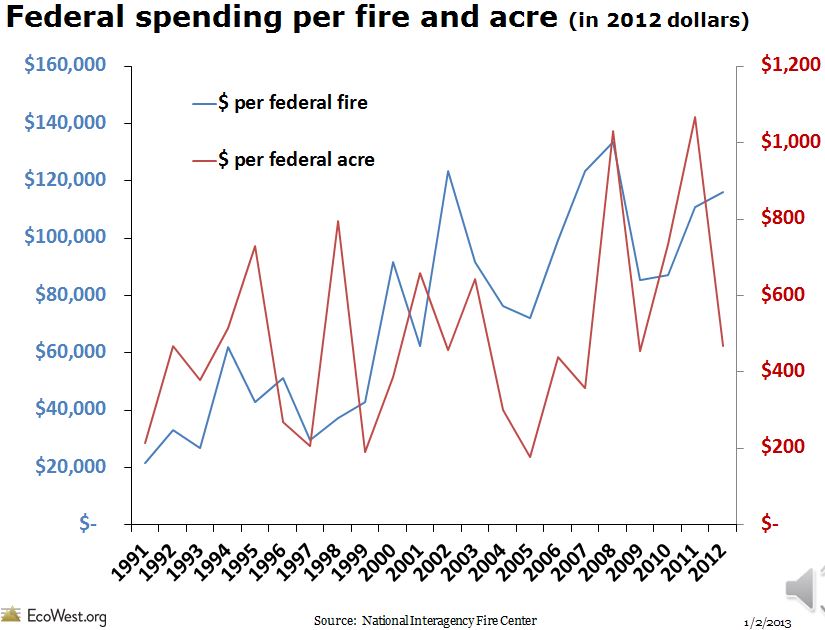


For more fire prevention tips visit www.firesafesanmateo.org or www.PreventWildfireCA.org.
Recent wildfire events throughout the world have highlighted the consequences of residential development in the wildland-urban interface (WUI) including hundreds to thousands of homes burned during a single wildfire to, more tragically, firefighter and homeowner fatalities. Despite substantial investments in modifying wildland fuels near populated areas, losses appear to be increasing. In this article, US Forest Service Researchers examine the conditions under which WUI wildfire disasters occur and introduce a wildfire risk assessment framework. By using this framework, the authors examine how prefire mitigation activities failed to prevent significant structure loss during the Fourmile Canyon fire outside Boulder, CO. In light of these results, the authors suggest the need to reevaluate and restructure wildfire mitigation programs aimed at reducing residential losses from wildfire.
ABSTRACT
Recent fire seasons in the western United States are some of the most damaging and costly on record. Wildfires in the wildland-urban interface on the Colorado Front Range, resulting in thousands of homes burned and civilian fatalities, although devastating, are not without historical reference. These fires are consistent with the characteristics of large, damaging, interface fires that threaten communities across much of the western United States. Wildfires are inevitable, but the destruction of homes, ecosystems, and lives is not. We propose the principles of risk analysis to provide land management agencies, first responders, and affected communities who face the inevitability of wildfires the ability to reduce the potential for loss. Overcoming perceptions of wildland-urban interface fire disasters as a wildfire control problem rather than a home ignition problem, determined by home ignition conditions, will reduce home loss.
“If our problem statement is defined a keeping wildfires out of the WUI, it is unobtainable, and large wildfires and residential disasters will continue, and likely increase. Fuel treatments do not stop fires (just change behavior), and treatment alone without Home Ignition Zone [HIZ] treatment means that the inevitable wildfire exposure will result in structure loss……..By contrast, if the problem is identified as a home ignition, mitigation of the HIZ is the most cost-effective investment for reducing home destruction, and this can be augmented with other investments.”
Tthe MidPeninsula Regional Open Space District Board of Directors approved a new 40-year Vision Plan January 29, 2014. Among the Vision Plan's priorities are Fire Management, Fire Risk Reduction, and Fire Risk Reduction on open space properties in San Mateo County.
The Vision Plan includes a slate of 25 tier-one regional open space projects ranging from opening preserves and building trail connections to improving water quality, protecting the coastline, restoring forestlands, and creating wildlife corridors in an increasingly urbanized region.
A complete list of the approved Vision Plan Priority Actions can be found at www.openspace.org/imagine.
Fire Safe San Mateo County is proud of its strong working relationship with "MidPen" and looks forward to a continued partership in reducing the risk of wildfire on MidPen lands and the adjacent San Mateo County communities.
Today the California Fire Safe Council announced grants for 38 projects spanning 30 counties in California and Nevada that support CFSC’s efforts to support fire risk reduction activities by landowners and residents in at-risk communities. CFSC received 84 applications, and awarded 38 grants.
Fire Safe San Mateo County was awarded $58,580 with a match of $65,200 for education and fuel reduction. The grant will help fund and expand an existing chipper program, providing additional vegetation removal and chipping county wide, and will fund a variety of related print and web based communication tools. No other proposals in San Mateo County were funded
California Fire Safe Council (CFSC) is pleased to announce its 2014 Grants Clearinghouse Awards. Executive Director Margaret Grayson announced grants for 38 projects spanning 30 counties in California that support CFSC’s efforts to support fire risk reduction activities by landowners and residents in at-risk communities in California and Nevada. The decisions that have been made are preliminary funding decisions at this time based on funding and the next steps in the Clearinghouse.
CFSC received 84 applications totaling $8 million in grant requests and over $10 million in matching dollars. The projects are being funded by grants from the Cooperative Fire Program of the U.S. Forest Service, Department of Agriculture, Pacific Southwest Region, through the California Fire Safe Council.
Click here to view the grant summary report on the 2014 Grant Awards and the list of preliminary funded projects.
With the change in seasons, fall is an excellent time to focus “inward” on the areas closest to your home, according to the latest issue of the Firewise “How-To” Newsletter.
In the Home Ignition Zone (HIZ), debris can accumulate creating a greater risk in the event that embers or flames come near. While the Home Ignition Zone typically includes property within 150 feet of your home, concentrating on the areas closest to your home – 0 to 5 feet from structures – can make a tremendous difference when it comes to preventing the risk of fire.
For more safety tips and to read the full story, check out the Fall 2013 issue of the Firewise “How-To” Newsletter.
They are called grass fires, forest fires, wildland fires, or by a variety of names. Yet, no matter the name, they pose an evolving threat to lives and property in an increasing number of communities across the United States.
Homes near natural areas, the wildland/urban interface (WUI), are beautiful places to live. These pristine environments add to the quality of life of residents and are valued by community leaders seeking to develop new areas of opportunity and local tax revenue, but these areas are not without risk. Fires are a part of the natural ecology, living adjacent to the wilderness means living with a constant threat of fires. Fire, by nature, is an unpredictable and often uncontrollable force.
The concept of fire-adapted communities (FACs) holds that, with proper community-wide preparation, human populations and infrastructure can withstand the devastating effects of a wildland fire, reducing loss of life and property.
This goal depends on strong and collaborative partnerships between agencies and the public at the State, Federal, and local levels, with each accepting responsibility for their part.
Your Role in Fire-Adapted Communities frames the FAC concept and current efforts to define its scope, explain the roles that groups can adopt to improve their fire safety, and provide guidance on future steps. The U.S. Fire Administration (USFA) believes that by reviewing the roles and responsibilities each group can adopt now, communities will become better prepared to realize the FAC goal in the future.
Download the U.S. Fire Administration "Your Role in Fire-Adapted Communities" Handbook.
As part of its commitment to enhancing public safety, NFPA makes its codes and standards available online to the public for free. Online access to NFPA's consensus documents conveniently places important safety information on the desktops of traditional users as well as others who have a keen interest. NFPA is committed to serving the public's increasing interest in technical information, and online access to these key codes is a valuable resource.
To review codes and standards online:

...Fire has always been a part of the natural ecology — many plant species evolved in direct response to it and couldn’t survive without it; when the sap of some pine cones melts, for example, seeds are released. But the reflexive practice of putting out all fires, which has dominated national policy for so many decades, has turned much of the American West into a tinderbox. On June 30, in the deadliest incident in wild-land firefighting in decades, 19 of the country’s most highly trained, highly skilled firefighters died in a fire near Yarnell, Ariz. While awaiting the findings from a federal investigation (expected this month), many have asked whether unexpected changes in the wind’s direction and speed, which abruptly exposed the men to the fire, were simply the most immediate factors contributing to their deaths. The Phoenix New Times, for instance, reported that the team should not have been deployed at all that day because its members may have already reached the maximum number of consecutive days they were allowed to be in the field. What’s clear, however, is that the buildup of flammable materials in the area and the ongoing drought in the Southwest contributed to the fire’s intensity. And it was a fire the firefighters were combating there in order to protect a housing subdivision on the outskirts of town...
...We probably wouldn’t be as concerned about fires that are getting bigger and spreading farther, of course, were it not for the increasing intrusion of people and buildings into fire-prone landscapes. This development creates what fire experts call the wild-land-urban interface, or WUI (pronounced WOO-ee), and from Bozeman, Mont., to Laurel Canyon in California, more and more of us want to live there, with forested views and coyotes for neighbors — but without the fire. About 80,000 wildfires in the United States were designated for suppression each year between 1998 and 2007, and only an average of 327 were allowed to burn. Yet trying to put out all those fires leads inevitably to more intense, more dangerous and more expensive fires later on. The accumulation of dead wood and unburned “ladder fuels” — what ecologists call lower vegetation that can carry fire to taller trees — turn lower-intensity fires into hotter fires that kill entire stands of trees that otherwise might survive.
Read more of this excellent article in the New York Times Magazine September 22, 2013 Online.
Destructive wildfires are affecting many areas across California, threatening communities, risking the lives of firefighters, disrupting residents through evacuations and home losses, and creating millions of dollars of damage to homes, businesses and valuable natural resources. The good news is, there are simple and often inexpensive ways to make homes safer from wildfire. With an understanding of wildfire hazards and mitigation strategies, community residents can effectively lower the wildfire risk and losses to their homes, neighborhoods and our environment.
The Sacramento (California) Metropolitan Fire Department has received a FEMA grant to complete Community Wildfire Protection Plans (CWPPs) and as a part of that effort is offering the National Fire Protection Association’s (NFPA) one-day “Assessing Residential Wildfire Hazards” and two-day “Assessing Wildfire Hazards in the Home Ignition Zone”mitigation training to fire service professionals, stakeholders, proactive community residents and others interested in understanding and acting to reduce wildfire losses.
These national courses are taught by experienced wildland fire specialists and offer factual wildfire mitigation solutions and action strategies based on research and post fire investigations. Participants will learn the mitigation techniques that are most effective in reducing wildfire losses in the home ignition zone (HIZ) – the home and the surrounding 100 to 200 feet. The courses will also focus on both the physical and behavioral sciences in completing successful wildfire mitigation.
Register today for workshops beginning October 1.
For more information and to find the nearest workshop location, visithttp://metrofirecwpp.
The summer season means more than school vacations and weekends at the pool. Summer brings an increase in the threat of wildfires and the danger that these outbreaks carry. As firefighters worked to contain wildfires across California, the National Interagency Fire Center recently published its summer fire outlook that forecasts a difficult, above average wildfire season in the West.
Wildfires spread quickly and often go undetected until it’s too late. Across our nation every year communities are affected by major wildfires. While some homes survive, more homes do not. Make sure your family and community take actions to get prepared.
The wildfire tips at Ready.gov reference the NFPA Firewise program and other excellent resources to help you prepare your home and know what to do before, during and after a fire event.
Headwaters Economics, a nonpartisan economic research center in Montana, published an excellent summary on the rising costs of wildland fires in the West. Their extensive analysis covers several areas in detail:
http://headwaterseconomics.org/wildfire/fire-research-summary

A wildfire-safe home must be an ember-ignition-resistant home, so that even if the flames do not reach your home, it will be able to withstand exposure to embers that may have been blown a mile or more in front of a wildfire. To provide maximum wildfire protection for your home, a combination of near-home vegetation management, appropriate building materials, and related design features must be used. These points are summarized the excellent Univesity of California publication, "Home Survival in Wildfire-Prone Areas: Building Materials and Design Considerations."
Preparing and maintaining adequate defensible space will guard against flame contact and radiant exposures from nearby vegetation—but because of the likely ember exposure to your home during a wildfire, you cannot ignore building material and design considerations. Similarly, if you ignore your defensible space (i.e., you do not have it or do not maintain it), the wildfire will produce maximum ember, flame, and radiant exposures to your home. It is very unlikely that even hardened buildings can survive such exposure, as a weak link will likely exist somewhere in the building enclosure.
Fire Safe San Mateo partners with CAL FIRE and California Department of Corrections and Rehabilitation (CDCR) to conduct fuel reduction and vegetation management projects in San Mateo County. With 17 members and a Fire Captain, Fire Crews are one of the most efficient resources available to create fuel breaks and conduct mechanical thinning of overgrown vegetation.
Project sponsors working with CAL FIRE crews in San Mateo County must have a form FC-31 (MOU) and FC-32 signed and on file with CAL FIRE.
The Sponsor shall submit project proposals on a form approved by CAL FIRE (currently an FC-32). By doing so, with reference to any such proposals subsequently approved by the CAL FIRE, Sponsor agrees to:
For residents living in the WUI, being closer to nature offers many benefits, but the risk of wildfires is often overlooked. NFPA's new best practices guide, Community Wildfire Safety through Regulation, provides options for planners and local communities considering wildfire regulations and the resources to help them adopt effective WUI tools that match local needs.
This guide is designed to help planners and local communities considering wildfire regulations to understand their options and implement a successful public process to adopt effective WUI tools that match local needs.
Fire departments work with reduced budgets and limited resources for fighting fire, but are still challenged with finding innovative ways to help protect their communities including working together with residents in wildfire risk mitigation activities.
NFPA’s new DVD, Before the Smoke! Preparing Your Community for Wildfire, highlights the work of three local fire departments whose ongoing relationship with their residents allowed them to create a community better prepared for the threat of wildfire. The DVD also provides important information about key programs that communities can engage in during the year including Firewise® and Ready, Set, Go, which are a part of the Fire Adapted Communities® initiative.
Watch a clip of the DVD below:
The DVD can found on NFPA's wildfire safety online catalog.
NFPA also provides other materials to help guide your mitigation activities with neighbors and friends.

More than 72,000 communities in the U.S. are located in high-risk wildfire areas, according to the 2012 National Association of State Foresters' Communities at Risk report. The report, which provides a national snapshot of wildland fire risk, preparedness and capacity, is the result of a survey of all states to determine the progress in identifying communities threatened by wildfire and the ongoing development of Community Wildfire Protection Plans.
The National Association of State Foresters (NASF) recently published the FY 2012 Communities at Risk (CAR) report. The purpose of the report is to determine progress in identifying communities at risk and developing Community Wildfire Protection Plans (CWPPs).
FIRE SAFE San Mateo has launched our presence onto Facebook and Twitter, where we will share updates on our projects and relevant wildfire prevention information to residents and visitors to San Mateo County.
Please Like Us on Facebook, and Follow Us on Twitter to keep up to date.
Join the International Association of Fire Chiefs Thursday, April 18 at 11 am ET, as they present Lessons from the Waldo Canyon Fire to consider how Colorado Spring’s wildland fire safety programs might be applied in your community.
Last summer, the Waldo Canyon Fire destroyed 345 homes and resulted in the evacuation of more than 30,000 residents from the city of Colorado Springs. In the wake of the tragic fire, members of the Fire Adapted Communities (FAC) Coalition visited the area to learn how the city’s decade-long wildland fire safety programs had affected the outcome of the fire. A final report and video were recently released as result of interviews, field visits and tours of the city’s most affected neighborhoods the Coalition’s assessment team conducted during the three-day visit to the area in July 2012.
The challenges presented by wildfire today, from the heavy vegetation on forests and rangelands to the communities at risk situated near these tinderboxes, are simply too complex to solve alone. To address these challenges, a broad cross-section of stakeholders has formed A National Cohesive Wildland Fire Management Strategy…
The Western Regional Action Plan is part of the culmination of a three-year effort put into motion by the Federal Land Assistance, Management and Enhancement Act of 2009 (FLAME Act). Representatives of federal, state, local, and tribal governments, scientists, interested governmental and nongovernmental organizations, businesses and industries worked together to develop a regional approach to achieving the goals of the National Cohesive Wildland Fire Management Strategy: Restore and Maintain Landscapes, Fire Adapted Communities, and Wildfire Response. The Western Regional Action Plan was developed with stakeholder input in an inclusive and transparent process. It is a dynamic document that will be updated continually and modified on a five-year basis to best focus on the issues of concern in terms of wildland fire in the West.
Ecological effects of alternative fuels treatments: Highlights from the Fire and Fire Surrogates study. February 2013.
McIver, J.D.; Stephens, S.L.; Agee, J.K.; et al. 2013. Ecological effects of alternative fuel-reduction treatments: highlights of the National Fire and Fire Surrogates (FFS) study. International Journal of Wildland Fire, 22(1): 63-82.
High-severity wildfire effects on carbon stocks and emissions in fuels treated and untreated forest. February 2013.
North, M. and M. Hurteau. 2011. High-severity wildfire effects on carbon stocks and emissions in fuels treated and untreated forest. Forest Ecology and Management. 261: 1115-1120.
Trees are an essential part of California's climate and are vital to improving the state's air quality and water conservation. To help educate Californians on the value that trees provide to building successful, healthy cities and neighborhoods, California celebrats March 7-14 of each year as California Arbor Week.
Homes with defensible space have a much greater chance of surviving a wildfire than homes without. Fire Safe San Mateo encourages you to give your house a fighting chance during a potential wildfire by establishing defensible space around your home. Defensible space breaks up the continuous path of plants that could carry wildfire to your home. And it gives firefighters a safe zone from which to fight a wildfire. It’s worth your effort.
A recent research article in the latest Society of American Foresters Journal of Forestry, December 2012 discusses the importance of community wildfire protection planning in engaging residents and other stakeholders in efforts to address their mutual concern about wildland fire management, hazardous fuel and forest health project prioritization. It was interesting to note that of the 13Community Wildfire Protection Plans (CWPP) that were studied 7 of these communities have one or more recognized Firewise Communities/USA® sites located within the geographical bounds of the CWPP planning area .
The NFPA's Wildland Fire Operations Division's recently released a report titled Engaging Youth in Reducing Wildfire Risk. Their blog examines why middle and high school students can and should have a role in reducing wildfire risk in the communities where they live. The report looks at existing programs throughout the country, youth preparedness research, findings from a series of six interactive workshops with students living in areas impacted by wildfire and a questionnaire distributed to teachers in four communities that recently experienced a wildland fire event.