Fire Safe San Mateo News
Wildfire Safety Blog and News from Fire Safe San Mateo.
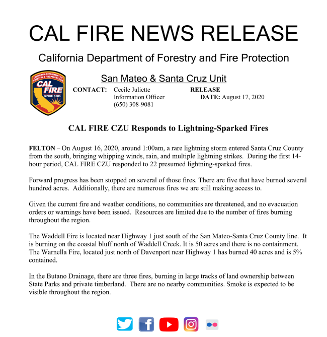
Aug
17
Jul
10
PG&E has provided information about their Community Wildfire Safety Program, which includes information for residents.
Please follow the link here: Community Wildfire Safety Program.
Jul
10

Earlier this year, Stanford's Bill Lane Center for the American West had planned an in-person Workshop on Wildfire Management. It was reformated into a virtual workshop that includes a recorded keynote presentation "What Motivates Homeowners to Mitigate Fire Risk? Lessons from Social Science" and two recorded pannel discussions, "Wildfire Management and Preparation during the COVID-19 Pandemic" and "Preparedness adn Recovery: The Human Dimensions of Wildfires". In addition, there are student poster presentations of original wildfire-related research available for viewing.
Please follow the link to access this resource: Wildfire in the West: Workshop on Wildfire Management (virtual format)
Apr
02
At the March Fire Safe meeting, Dr. Matteo Garbelotto of UC Berkeley presented the lates information about SOD (Sudden Oak Death) and its relationship to fire ecology (please see meeting notes from March 2020 for a recap). Dr. Garbelotto also invited anyone interested to participate in the annual SOD Blitz which is run by his research program at UC Berkeley.
In light of the recent COVID-19 shelter-in-place order, Dr. Garbelotto provided us an update that the SOD Blitzes for 20202 will still be running, using new and approved guidelines.
Copied below is his message with more details:
March 31st, 2020
Concerned Californians, nature-lovers and environmentalists,
You are receiving this email because in the past you have attended one of the many programs offered by the U.C. Berkeley Forest Pathology and Mycology Laboratory (www.matteolab.org<http://www.matteolab.org>). I know many of you have participated in at least one annual SOD Blitz. SOD Blitzes have grown to become the gold standard in the field of Citizen Science programs aimed at protecting forest health, and you –the volunteers- are the main reason for this success. SOD Blitzes allow us to map the distribution of Sudden Oak Death (SOD) throughout the State each year. Mapping SOD in 2020 may be critical for various reasons: 1)- Areas with recent SOD mortality are much more prone to support extremely hot wildfires; 2)- SOD infected oaks fail, often when still green, with obvious consequences for property and people; 3)- Knowing where SOD is, allows local residents to choose to protect their oaks using science-proven disease management options; 4)- Two new strains of the diseases are looming at the edge of California forests and the SOD Blitzes are the only way to intercept them before they spread. These new strains could be a game changer in the negative sense of the expression.
In spite of the ongoing health scare and of the statewide “Shelter in Place” ordinance, we have been able to redesign the 2020 SOD Blitzes to make them 100% safe and legal, an effective activity that allows you to exercise, and –of course- a powerful Citizen Science program that will help all of us protecting our forests. The program has received full approval by U.C. Berkeley and it will go on as long as we all follow the simple guidelines posted at www.sodblitz.org<http://www.sodblitz.org>. All of the training and free registration will be done online, you will pick up fully sterile collection and survey materials at a local SOD Blitz Station, conveniently located near a parking lot, and you will return your samples at the same SOD Blitz station or by mail, depending on where you are. All the precise information is available at www.sodblitz.org<http://www.sodblitz.org>. Remember, by participating in your local SOD Blitz, you will get a chance to exercise in nature while helping protecting our forests through a 100% safe activity.
Social distancing and clean “housekeeping” rules are strongly enforced, so when picking up or returning materials and stay at least 6 feet away from other volunteers. You will be allowed to survey and sample trees in private properties with the owners’ consent, along roads (be mindful of approaching vehicles), and in parks that may still be open to the public. Again, respect social distancing rules in the field as well. Do participate, because Sudden Oak Death is not stopping and we need to be proactive about it in order to succeed in our efforts to preserve our beloved oaks for future generations. In 2019 alone, more than one million trees were killed by SOD. Go to www.sodblitz.org<http://www.sodblitz.org> to familiarize yourselves with the easy-to-follow new SOD Blitz guidelines, and to find out the time slot that has been assigned to your neighborhood to perform the survey. This is an activity you can do with the entire family or with one friend: do not miss out the opportunity to be part of the solution.
Matteo Garbelotto Ph.D.
Director U.C. Berkeley Forest Pathology and Mycology Laboratory Statewide U.C. Forest Pathology Extension Specialist Adj.Professor, Department of ESPM www.matteolab.org<http://www.matteolab.org>
Apr
02
Mipeninsula Regional Open Space District wiil be having a virtual public meeting about their Wildland Fire Resiliency Program. This is an opportunity to learn more and provide actions.
Information from Midpen:
Now is a great time to comment on the Midpeninsula Regional Open Space District's Wildland Fire Resiliency Program.This proposed program will proactively expand our environmentally sensitive vegetation management to establish healthy, resilient ecosystems; reduce fire risk; and facilitate fire suppression.
Please join Midpen's board of directors for a study session:
Wednesday, April 8, 2020, 5-7 p.m.
Virtual meeting, click here for details<https://openspace.us1.list-manage.com/track/click?u=cf60d90ac20de1d557d559b1e&id=a02e2e2fa4&e=fa82987005>
No board action will be taken
This is an opportunity to learn more about and comment on program components including:
- Vegetation management plan
- Prescribed fire plan
- Monitoring plan
- Preserve maps for fire agencies
Due to shelter-at-home orders this will be a virtual meeting. Details and instructions on how to comment and participate<https://openspace.us1.list-manage.com/track/click?u=cf60d90ac20de1d557d559b1e&id=4bf75f5b33&e=fa82987005> can be found on our website.
For more information contact project manager Coty Sifuentes-Winter at This email address is being protected from spambots. You need JavaScript enabled to view it. or 650-625-6560.
Feb
13
Check out a few upcoming events of interest to FIRE SAFE San Mateo County members! These events are not affiliated with FIRE SAFE San Mateo County, but are wonderful opportunity for members to learn and network throughout the region.
Protecting Your City from Wildfire
Crowne Plaza San Diego
Wednesday, March 11 - Thursday, March 12, 2020
This meeting has been organized to provide city administrations with best practices and expert advice on developing community wildfire protection plans, engaging and educating residents, and hardening existing systems to increase resilience. It is now more important than ever for cities and communities to coordinate with police, water, fire, public health, electric utility, and other local, state, and federal agencies.
Attend this meeting to learn best practices in order to respond to the risk of wildfires. Cities will learn how to work aggressively and proactively on plans to mitigate avoidable risk, coordinate with many public agencies, and make strategic investments to render your city able to provide essential services and protect the life and property of your citizens.Conference Website.
Workshop on Wildfire Management: The Case of San Mateo and Santa Clara Counties
Stanford University
Monday, March 16, 2020
Stanford University invites local policymakers and resiliency staff to join for a one-day workshop on issues surrounding wildfires, building upon early efforts in San Mateo and Santa Clara Counties to identify risk and vulnerability and pivot to actionable solutions that can be implemented by cities. RSVP by Feb 21.
RESOURCE: Community Planning Assistance for Wildfire (CPAW)
https://planningforwildfire.org/
Established in 2015 by Headwaters Economics and Wildfire Planning International, Community Planning Assistance for Wildfire (CPAW) works with communities to reduce wildfire risks through improved land use planning.
CPAW is a grant-funded program providing communities with professional assistance to integrate wildfire mitigation into the development planning process. The CPAW consulting team consists of foresters, land use planners, economists, and wildfire risk modelers who collaborate closely with community leaders and city officials to reduce wildfire risk.
Feb
13
Project Coodinator Position for Fuel Reduction Project

The South Skyline FireSafe Council (SSFSC) is seeking a Project Coordinator to facilitate and provide leadership for California Conservation Corps crews (CCC) on a fuel reduction project in the Long Ridge Open Space Preserve and adjacent Portola Heights community. Work is entirely on privately owned residential properties as well as land owned or managed by the Mid-Peninsula Open Space District (MROSD). The Coordinator will coordinate with the CCC crew supervisor, South Skyline FireSafe Council, CalFire, and MROSD staff as well as residents of the community to ensure compliance with SSFSC treatment specifications, to prioritize work, and to address special conditions that arise. This is a temporary position, although future SSFSC projects are anticipated that may lead to future work. Applicants will need a business license or may be “on loan” from another agency
Full Job Description Found Here: South Skyline Project Coordinator Job Posting
If you would like more information about this topic, please contact Debra Born at 650-917-9648 or email at debbborn [@] gmail.com.
Oct
02

Created to address fire risk on private property, Firewise USA is a national program that empowers homeowners to engage in fire prevention at a community level. This recognition program through National Fire Protection Association provides homeowners with an organized framework to plan, organize and implement fire prevention around their homes and communities. Homeowners can learn about wildfire, gain access to resources, and collaborate with neighbors to provide their community with a framework for action. There are even some opportunities for fire insurance discounts. In participating, communities join over 1,500 other Firewise USA sites in 42 states who volunteer yearly to decrease their risk of fire.
Firewise USA representative, David Shew, presented to the September 11th, 2019 Fire Safe San Mateo County meeting on general information about the program for San Mateo County residents. If you missed the September meeting, you can still view the powerpoint presentation below.
To have your community recognized as a Firewise USA site or to learn more, visit NFPA.org.
.
Jul
23
Dr. Craig Clements from the Fire Weather Research Laboratory at San Jose State University gave a presentation on fire weather and fire science at the July 10th meeting. The Fire Weather Research Laboratory is the only academic fire weather program in the United States. Dr. Clements conducts research on extreme fire behavior and fire weather and his program collects observational data on wildfires and experimental fires. The program develops ways to understand weather created by fires and how other weather patterns can be used to predict where and when fires will occur. He also discussed other data gathering and monitoring his program carries out, including live fuel moisture monitoring and fire weather research field sites.
Jun
12

We were delighted to have our guests from Sonoma County come down for our Fire Safe San Mateo County workshop Wednesday, June 12th, 2019. In anticipation for a collaborative, multi-agency County-wide vegetation mapping project "San Mateo County Vegetation Map and Landscape Database Project", guests spoke upon the current progress of the mapping project within San Mateo County and applicative uses for the maps, focusing on fuel load and fire modeling from Sonoma County's mapping project. We've summarized our guest's presentations below.
The ultimate goals of the San Mateo vegetation mapping project are large and ongoing. So far, the project has been able to produce high resolution imagery and LiDar data, a method of remote sensing that creates a 3-D representation of the landscape. From these original data sets, and with the help from an army of botanists, the project aims to produce fine scale vegetation type maps, fire fuels mapping, relative forest stand cover, impervious surfaces layer mapping, hydrologic system mapping and topographic modeling and contours. With enough funding, more maps can created from the original data. Altogether, the applicative uses of the data produced will be limited to the imagination. Ultimate completion of the project is slated for January 2022. The final maps (available in GIS format) will be available at San Mateo County's GIS webportal.
In Sonoma County, a similar mapping project was completed in 2017. The final product is provided not only as downloadable packages, but also through a user friendly mapping webportaland "Story Map". These easy to use maps bring the wealth of information this project brings to the greater public, including local government, State government, academia, communities, Resource Conservation Districts, non-profits and commercial entities. This data has been used for a myriad of reasons, spanning wetland conservation, agricultural protection, old-growth redwood research, carbon sequestration research, floodplain and creek restoration and planning along with so much more. Check out their website at sonomavegmap.org.
Following the 2017 Sonoma Complex fires which started October 8th, 2017, Sonoma suffered devastating impacts from the combined destruction from the Pocket, Tubbs and Nuns Fire. In the aftermath, there were many questions as to why the fires spread the way they did and with such destructive force. Fires are not new to Sonoma County, there have been multiple historical fires, predominantly in 1924 and 1963, that match similar footprints to both the Nuns and Tubbs Fire. However, there's no question that these fires are beyond the extent of any historical fire. To answer the question, "why?", a collaborative effort was created through Ag and Open Space Sonoma County with Kass Green & Associates with Tuckman Geospatial. Their hypothesis was the changes in the landscape, such as slope, vegetation, wind and ladder fuels, were responsible for heightened intensity and spread of the fires. With funding assistance through NASA, the research team investigated the relationship between damage to the landscape (woody canopy) and variations across the landscape. Using machine learning, the research team looked at 72 landscape variables, including ladder fuels, canopy height, wind direction and speed, and distance to streams.
Out of the six scenarios (each of the three fires being divided by wind driven events and topography driven events) their machine learning algorithm found high density of ladder fuels, low canopy height (shrubs), low climatic water deficit (precipitation and overall moisture), and far distance from streams all correlated to high damage to the landscape. A large takeaway from these results is the importance of ladder fuels in intensifying wildfires. Ladder fuels are the accumulation of woody vegetation (fuel) underneath a forest or shrub canopy. From these ladder fuels, fire can "climb" from lower growing woody vegetation up into the canopy, causing a high-temperature crown fire. The fire prevention community has known ladder fuels increase the risk and intensity of wildfires for a long time. This study not only verifies this case, but also provides something greater—a means of mapping the ladder fuels through Sonoma County. With this map, Sonoma County is able to find and manage for ladder fuels, focusing on escape routes, homes and buildings.
For San Mateo County, we still have a few years to wait before we can create similar resources. Starting in Summer 2019, the data will be coming out piecemeal, like LiDar, 1-ft contours, and ladder fuels, but the final package is slated for 2022. Once fully produced, these maps will provide critical information to fire prevention agencies, such as Fire Safe San Mateo County, in planning escape routes, creating targeted fuel reduction projects around fire prone communities and so much more.
Special thank you to Danny Franco (Golden Gate National Parks Conservancy), Deborah Hirst (Board of Supervisors for District 3), Supervisor Don Horsley, Denise Enea (Woodside Fire Protection District and Fire Safe San Mateo County Board President) and the good folks at Woodside Town hall for all your work in creating this workshop.
For more information on the San Mateo vegetation mapping project, please contact Daniel Franco at This email address is being protected from spambots. You need JavaScript enabled to view it.. Power point presentation from the day's presentations are available here: