Fire Safe San Mateo News
Wildfire Safety Blog and News from Fire Safe San Mateo.
Aug
26
Aug
26
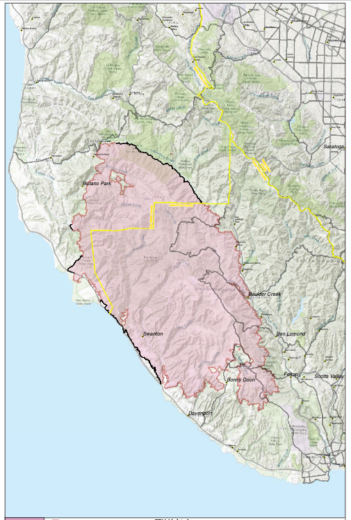
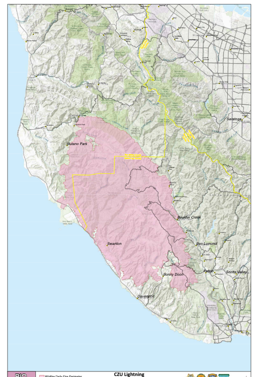
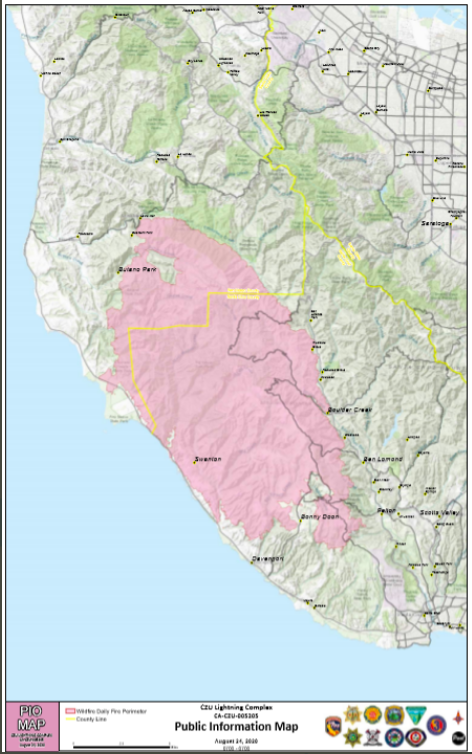
Perimeter map as of August 26, 2020
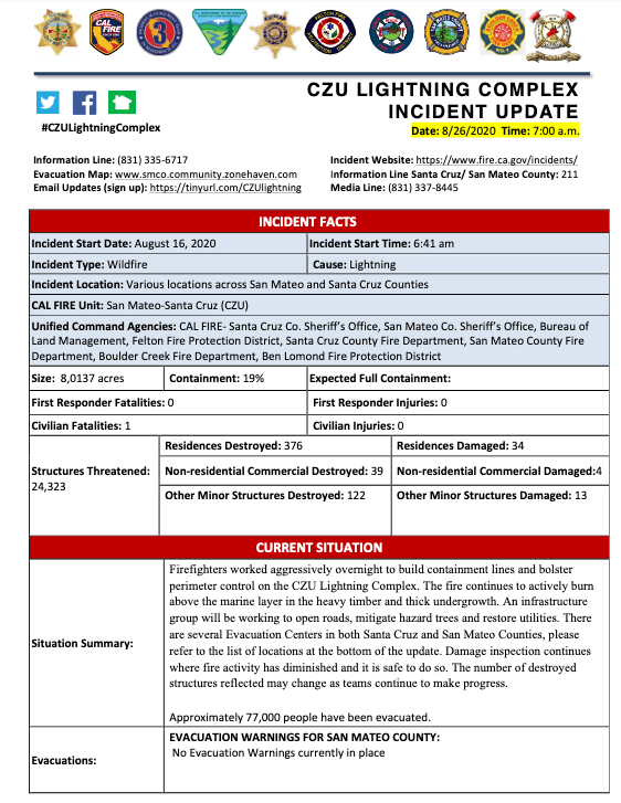
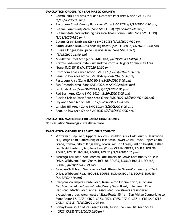
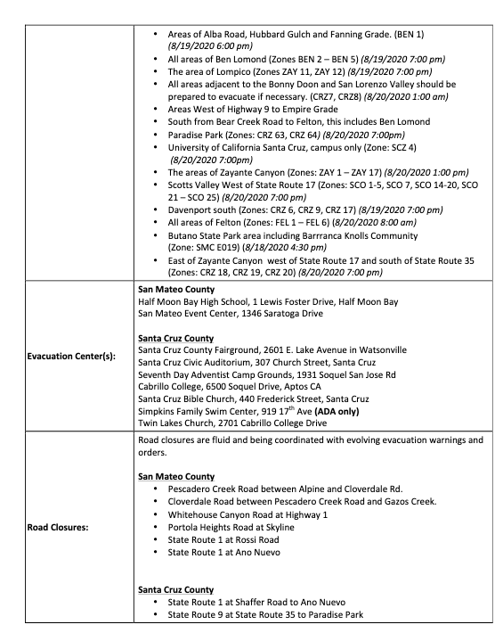
Incident Website: https://www.fire.ca.gov/incidents/
Evacuation Map:www.smco.community.zonehaven.com
Email Updates (sign up here):https://tinyurl.com/CZUlightning
Video update (press conference) in English: https://www.pscp.tv/CALFIRECZU/1mrxmEmejQZxy
Video update en Español: https://youtu.be/QJMbSQ19HWg
Aug
25
Incident Website: https://www.fire.ca.gov/incidents/
Evacuation Map: www.smco.community.zonehaven.com
Email Updates (sign up here): https://tinyurl.com/CZUlightning
Video update in English: https://youtu.be/n3SJhoxRIhc
Aug
25
 .
.
Aug
25
Link to incidence map (note: may take time to load): https://wildfirerecovery.caloes.ca.gov/current-incidents/
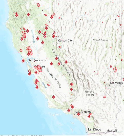
The current status of California fires since August 15, 2020 (information curent as of August 25, 2020). source: CZU Lightning Complex press conference Aug 25.
- 1.25 million acres of land has burned
- 136,000 people evacuated
- 100 aircraft assigned to fight fires
- 2.7 million gallons of retardant dropped
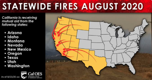
- Additional resources have been coming into CA from throughout western US
Aug
25
Incident Website: https://www.fire.ca.gov/incidents/
Evacuation Map: www.smco.community.zonehaven.com
Email Updates (sign up here): https://tinyurl.com/CZUlightning
Video of update, in English: https://www.youtube.com/watch?v=Hu2EaUdPnmI
Video update, en Español: https://youtu.be/KffU8aPrtuo
Aug
24
Incident Website: https://www.fire.ca.gov/incidents/
Evacuation Map: www.smco.community.zonehaven.com
Email Updates (sign up here): https://tinyurl.com/CZUlightning
Aug
24
Aug
24
To support our fellow community members, consider donating to:
Puente, which supports south coast families: https://mypuente.org
Coastside Hope, supports San Mateo County coastside residents: https://coastsidehope.org
ALAS (Ayudando Latinos A Soñar), supporting families, farmworkers, and youth of the coastside: https://www.alashmb.org
**note: goods are NOT being accepted at evacuation centers. Financial contributions are the highest need
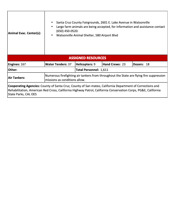
Animals are in need too:
Woodside Community Foundation is focused on rasing funds for large animal rescue resulting from these fire. For more information call Rick DeBenedetti, (650) 303-2661. Online donations accepted here: Woodsidegiving.org
Peninusla Human Society is accepting donations of pet food, cat litter, newspapers at their Coyote Point Shelter. 12 Airport Blvd, San Mateo. and financial donation here: https://phs-spca.org
San Mateo County Large Animal Evacuation Group is also requesting help to feed displaced animals. (note: not tax deductable). https://smclaeg.org/
Aug
24
Incident Website: https://www.fire.ca.gov/incidents/
Evacuation Map: www.smco.community.zonehaven.com
Email Updates (sign up here): https://tinyurl.com/CZUlightning


